You are here: Home > Network List > UO - University of Oregon Regional Network Stations List
> Station KING Golden, OR, USA > Earthquake Result Viewer
KING Golden, OR, USA - Earthquake Result Viewer
| Earthquake location: |
Tonga Islands Region |
| Earthquake latitude/longitude: |
-19.3/-172.1 |
| Earthquake time(UTC): |
2022/11/11 (315) 10:48:45 GMT |
| Earthquake Depth: |
25 km |
| Earthquake Magnitude: |
7.3 Mww |
| Earthquake Catalog/Contributor: |
NEIC PDE/us |
|
| Network: |
UO University of Oregon Regional Network |
| Station: |
KING Golden, OR, USA |
| Lat/Lon: |
42.69 N/123.23 W |
| Elevation: |
1596 m |
|
| Distance: |
76.4 deg |
| Az: |
34.851 deg |
| Baz: |
227.051 deg |
| Ray Param: |
0.051026724 |
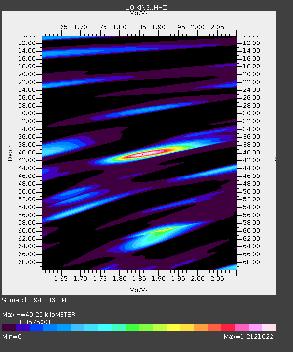
| Estimated Moho Depth: |
40.25 km |
| Estimated Crust Vp/Vs: |
1.86 |
| Assumed Crust Vp: |
6.522 km/s |
| Estimated Crust Vs: |
3.511 km/s |
| Estimated Crust Poisson's Ratio: |
0.30 |
|
| Radial Match: |
94.186134 % |
| Radial Bump: |
330 |
| Transverse Match: |
83.62118 % |
| Transverse Bump: |
400 |
| SOD ConfigId: |
29756493 |
| Insert Time: |
2022-11-25 11:28:12.665 +0000 |
| GWidth: |
2.5 |
| Max Bumps: |
400 |
| Tol: |
0.001 |
|

Signal To Noise
| Channel | StoN | STA | LTA |
| UO:KING: :HHZ:20221111T11:00:00.839976Z | 39.06128 | 6.4545056E-6 | 1.6524051E-7 |
| UO:KING: :HHN:20221111T11:00:00.839976Z | 10.445708 | 1.5558683E-6 | 1.4894809E-7 |
| UO:KING: :HHE:20221111T11:00:00.839976Z | 12.061191 | 2.23823E-6 | 1.8557289E-7 |
| Arrivals |
| Ps | 5.5 SECOND |
| PpPs | 17 SECOND |
| PsPs/PpSs | 23 SECOND |


