You are here: Home > Network List > US - United States National Seismic Network Stations List
> Station DGMT Dagmar, Montana, USA > Earthquake Result Viewer
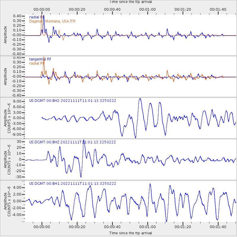
DGMT Dagmar, Montana, USA - Earthquake Result Viewer
*The percent match for this event was below the threshold and hence no stack was calculated.
| Earthquake location: |
Tonga Islands Region |
| Earthquake latitude/longitude: |
-19.3/-172.1 |
| Earthquake time(UTC): |
2022/11/11 (315) 10:48:45 GMT |
| Earthquake Depth: |
25 km |
| Earthquake Magnitude: |
7.3 Mww |
| Earthquake Catalog/Contributor: |
NEIC PDE/us |
|
| Network: |
US United States National Seismic Network |
| Station: |
DGMT Dagmar, Montana, USA |
| Lat/Lon: |
48.47 N/104.20 W |
| Elevation: |
0.0 m |
|
| Distance: |
90.5 deg |
| Az: |
38.072 deg |
| Baz: |
241.053 deg |
| Ray Param: |
$rayparam |
*The percent match for this event was below the threshold and hence was not used in the summary stack. |
|
| Radial Match: |
95.81511 % |
| Radial Bump: |
226 |
| Transverse Match: |
91.87101 % |
| Transverse Bump: |
297 |
| SOD ConfigId: |
29756493 |
| Insert Time: |
2022-11-25 11:28:30.535 +0000 |
| GWidth: |
2.5 |
| Max Bumps: |
400 |
| Tol: |
0.001 |
|
Signal To Noise
| Channel | StoN | STA | LTA |
| US:DGMT:00:BHZ:20221111T11:01:13.325022Z | 19.516714 | 6.0087827E-6 | 3.0787882E-7 |
| US:DGMT:00:BH1:20221111T11:01:13.325022Z | 0.86800796 | 5.517301E-7 | 6.3562794E-7 |
| US:DGMT:00:BH2:20221111T11:01:13.325022Z | 2.1061404 | 1.7019506E-6 | 8.0808985E-7 |
| Arrivals |
| Ps | |
| PpPs | |
| PsPs/PpSs | |


