You are here: Home > Network List > US - United States National Seismic Network Stations List
> Station WUAZ Wupatki, Arizona, USA > Earthquake Result Viewer
WUAZ Wupatki, Arizona, USA - Earthquake Result Viewer
| Earthquake location: |
Tonga Islands Region |
| Earthquake latitude/longitude: |
-19.3/-172.1 |
| Earthquake time(UTC): |
2022/11/11 (315) 10:48:45 GMT |
| Earthquake Depth: |
25 km |
| Earthquake Magnitude: |
7.3 Mww |
| Earthquake Catalog/Contributor: |
NEIC PDE/us |
|
| Network: |
US United States National Seismic Network |
| Station: |
WUAZ Wupatki, Arizona, USA |
| Lat/Lon: |
35.52 N/111.37 W |
| Elevation: |
1592 m |
|
| Distance: |
79.2 deg |
| Az: |
46.412 deg |
| Baz: |
236.982 deg |
| Ray Param: |
0.04906781 |
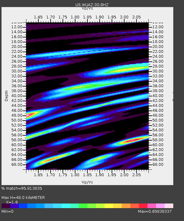
| Estimated Moho Depth: |
48.0 km |
| Estimated Crust Vp/Vs: |
1.60 |
| Assumed Crust Vp: |
6.207 km/s |
| Estimated Crust Vs: |
3.879 km/s |
| Estimated Crust Poisson's Ratio: |
0.18 |
|
| Radial Match: |
95.813835 % |
| Radial Bump: |
400 |
| Transverse Match: |
92.02064 % |
| Transverse Bump: |
400 |
| SOD ConfigId: |
29756493 |
| Insert Time: |
2022-11-25 11:29:22.067 +0000 |
| GWidth: |
2.5 |
| Max Bumps: |
400 |
| Tol: |
0.001 |
|

Signal To Noise
| Channel | StoN | STA | LTA |
| US:WUAZ:00:BHZ:20221111T11:00:16.898997Z | 20.751926 | 4.810815E-6 | 2.3182498E-7 |
| US:WUAZ:00:BH1:20221111T11:00:16.898997Z | 4.044167 | 6.593769E-7 | 1.6304392E-7 |
| US:WUAZ:00:BH2:20221111T11:00:16.898997Z | 6.542311 | 1.0871471E-6 | 1.6617173E-7 |
| Arrivals |
| Ps | 4.8 SECOND |
| PpPs | 20 SECOND |
| PsPs/PpSs | 24 SECOND |


