You are here: Home > Network List > UU - University of Utah Regional Network Stations List
> Station FSB3 FORGE surface borehole 3, UT, USA > Earthquake Result Viewer
FSB3 FORGE surface borehole 3, UT, USA - Earthquake Result Viewer
| Earthquake location: |
Tonga Islands Region |
| Earthquake latitude/longitude: |
-19.3/-172.1 |
| Earthquake time(UTC): |
2022/11/11 (315) 10:48:45 GMT |
| Earthquake Depth: |
25 km |
| Earthquake Magnitude: |
7.3 Mww |
| Earthquake Catalog/Contributor: |
NEIC PDE/us |
|
| Network: |
UU University of Utah Regional Network |
| Station: |
FSB3 FORGE surface borehole 3, UT, USA |
| Lat/Lon: |
38.51 N/112.88 W |
| Elevation: |
1701 m |
|
| Distance: |
79.9 deg |
| Az: |
43.202 deg |
| Baz: |
235.498 deg |
| Ray Param: |
0.04861714 |
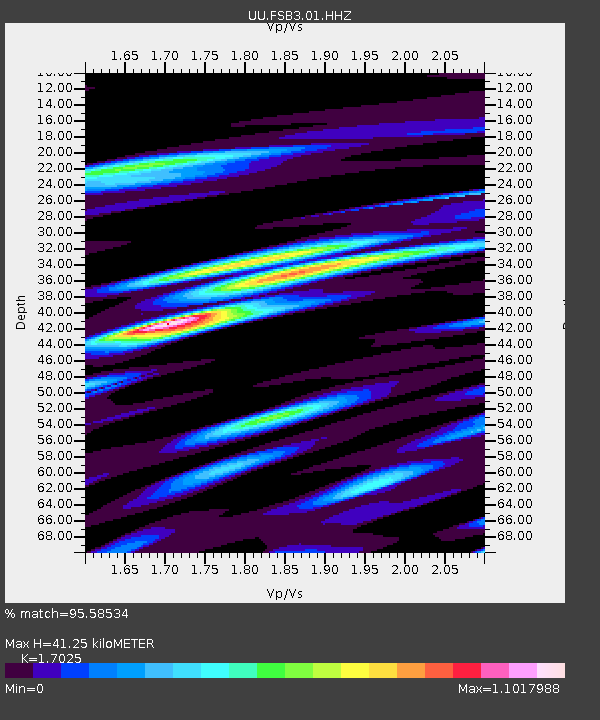
| Estimated Moho Depth: |
41.25 km |
| Estimated Crust Vp/Vs: |
1.70 |
| Assumed Crust Vp: |
6.276 km/s |
| Estimated Crust Vs: |
3.686 km/s |
| Estimated Crust Poisson's Ratio: |
0.24 |
|
| Radial Match: |
95.58534 % |
| Radial Bump: |
400 |
| Transverse Match: |
80.66631 % |
| Transverse Bump: |
400 |
| SOD ConfigId: |
29756493 |
| Insert Time: |
2022-11-25 11:29:41.405 +0000 |
| GWidth: |
2.5 |
| Max Bumps: |
400 |
| Tol: |
0.001 |
|

Signal To Noise
| Channel | StoN | STA | LTA |
| UU:FSB3:01:HHZ:20221111T11:00:20.445018Z | 22.405758 | 5.0231347E-6 | 2.2418945E-7 |
| UU:FSB3:01:HH1:20221111T11:00:20.445018Z | 6.181081 | 1.243026E-6 | 2.0110171E-7 |
| UU:FSB3:01:HH2:20221111T11:00:20.445018Z | 11.852745 | 1.9057011E-6 | 1.6078141E-7 |
| Arrivals |
| Ps | 4.7 SECOND |
| PpPs | 17 SECOND |
| PsPs/PpSs | 22 SECOND |


