You are here: Home > Network List > UU - University of Utah Regional Network Stations List
> Station MCU Monte Cristo, UT, USA > Earthquake Result Viewer
MCU Monte Cristo, UT, USA - Earthquake Result Viewer
| Earthquake location: |
Tonga Islands Region |
| Earthquake latitude/longitude: |
-19.3/-172.1 |
| Earthquake time(UTC): |
2022/11/11 (315) 10:48:45 GMT |
| Earthquake Depth: |
25 km |
| Earthquake Magnitude: |
7.3 Mww |
| Earthquake Catalog/Contributor: |
NEIC PDE/us |
|
| Network: |
UU University of Utah Regional Network |
| Station: |
MCU Monte Cristo, UT, USA |
| Lat/Lon: |
41.46 N/111.51 W |
| Elevation: |
2668 m |
|
| Distance: |
82.4 deg |
| Az: |
41.338 deg |
| Baz: |
236.09 deg |
| Ray Param: |
0.046862125 |
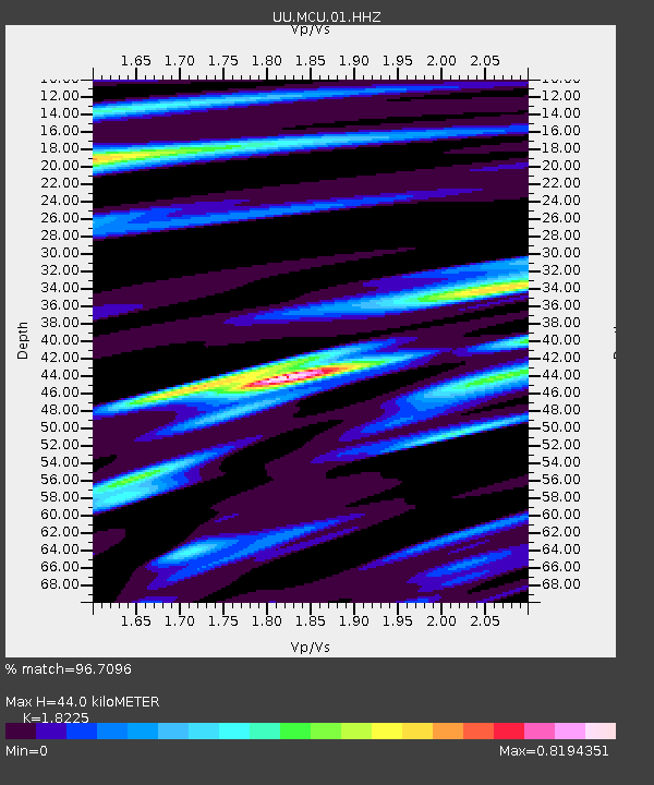
| Estimated Moho Depth: |
44.0 km |
| Estimated Crust Vp/Vs: |
1.82 |
| Assumed Crust Vp: |
6.155 km/s |
| Estimated Crust Vs: |
3.377 km/s |
| Estimated Crust Poisson's Ratio: |
0.28 |
|
| Radial Match: |
96.7096 % |
| Radial Bump: |
232 |
| Transverse Match: |
92.91049 % |
| Transverse Bump: |
381 |
| SOD ConfigId: |
29756493 |
| Insert Time: |
2022-11-25 11:29:54.095 +0000 |
| GWidth: |
2.5 |
| Max Bumps: |
400 |
| Tol: |
0.001 |
|

Signal To Noise
| Channel | StoN | STA | LTA |
| UU:MCU:01:HHZ:20221111T11:00:33.830027Z | 41.101677 | 7.739604E-6 | 1.8830386E-7 |
| UU:MCU:01:HHN:20221111T11:00:33.830027Z | 9.092549 | 1.104773E-6 | 1.215031E-7 |
| UU:MCU:01:HHE:20221111T11:00:33.830027Z | 13.622833 | 1.9063368E-6 | 1.3993689E-7 |
| Arrivals |
| Ps | 6.0 SECOND |
| PpPs | 20 SECOND |
| PsPs/PpSs | 26 SECOND |


