You are here: Home > Network List > UU - University of Utah Regional Network Stations List
> Station FOR8 FORGE > Earthquake Result Viewer
FOR8 FORGE - Earthquake Result Viewer
| Earthquake location: |
Tonga Islands Region |
| Earthquake latitude/longitude: |
-19.3/-172.1 |
| Earthquake time(UTC): |
2022/11/11 (315) 10:48:45 GMT |
| Earthquake Depth: |
25 km |
| Earthquake Magnitude: |
7.3 Mww |
| Earthquake Catalog/Contributor: |
NEIC PDE/us |
|
| Network: |
UU University of Utah Regional Network |
| Station: |
FOR8 FORGE |
| Lat/Lon: |
38.53 N/113.08 W |
| Elevation: |
1654 m |
|
| Distance: |
79.8 deg |
| Az: |
43.1 deg |
| Baz: |
235.357 deg |
| Ray Param: |
0.048695885 |
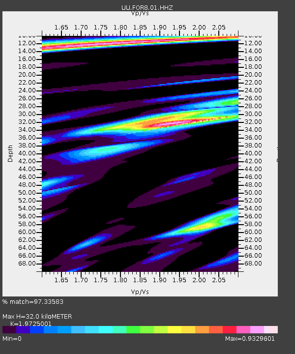
| Estimated Moho Depth: |
32.0 km |
| Estimated Crust Vp/Vs: |
1.97 |
| Assumed Crust Vp: |
6.276 km/s |
| Estimated Crust Vs: |
3.182 km/s |
| Estimated Crust Poisson's Ratio: |
0.33 |
|
| Radial Match: |
97.33583 % |
| Radial Bump: |
323 |
| Transverse Match: |
90.786865 % |
| Transverse Bump: |
400 |
| SOD ConfigId: |
29756493 |
| Insert Time: |
2022-11-25 11:30:00.341 +0000 |
| GWidth: |
2.5 |
| Max Bumps: |
400 |
| Tol: |
0.001 |
|

Signal To Noise
| Channel | StoN | STA | LTA |
| UU:FOR8:01:HHZ:20221111T11:00:19.805003Z | 44.575386 | 6.440993E-6 | 1.4449662E-7 |
| UU:FOR8:01:HHN:20221111T11:00:19.805003Z | 8.331186 | 1.508243E-6 | 1.8103582E-7 |
| UU:FOR8:01:HHE:20221111T11:00:19.805003Z | 4.050987 | 1.5829431E-6 | 3.9075496E-7 |
| Arrivals |
| Ps | 5.1 SECOND |
| PpPs | 15 SECOND |
| PsPs/PpSs | 20 SECOND |


