You are here: Home > Network List > UW - Pacific Northwest Regional Seismic Network Stations List
> Station GNW Green Mountain (BB) > Earthquake Result Viewer
GNW Green Mountain (BB) - Earthquake Result Viewer
| Earthquake location: |
Tonga Islands Region |
| Earthquake latitude/longitude: |
-19.3/-172.1 |
| Earthquake time(UTC): |
2022/11/11 (315) 10:48:45 GMT |
| Earthquake Depth: |
25 km |
| Earthquake Magnitude: |
7.3 Mww |
| Earthquake Catalog/Contributor: |
NEIC PDE/us |
|
| Network: |
UW Pacific Northwest Regional Seismic Network |
| Station: |
GNW Green Mountain (BB) |
| Lat/Lon: |
47.56 N/122.83 W |
| Elevation: |
160 m |
|
| Distance: |
79.9 deg |
| Az: |
31.42 deg |
| Baz: |
226.632 deg |
| Ray Param: |
0.04862128 |
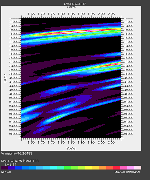
| Estimated Moho Depth: |
16.75 km |
| Estimated Crust Vp/Vs: |
1.87 |
| Assumed Crust Vp: |
6.566 km/s |
| Estimated Crust Vs: |
3.511 km/s |
| Estimated Crust Poisson's Ratio: |
0.30 |
|
| Radial Match: |
96.26483 % |
| Radial Bump: |
228 |
| Transverse Match: |
87.740875 % |
| Transverse Bump: |
383 |
| SOD ConfigId: |
29756493 |
| Insert Time: |
2022-11-25 11:30:50.285 +0000 |
| GWidth: |
2.5 |
| Max Bumps: |
400 |
| Tol: |
0.001 |
|
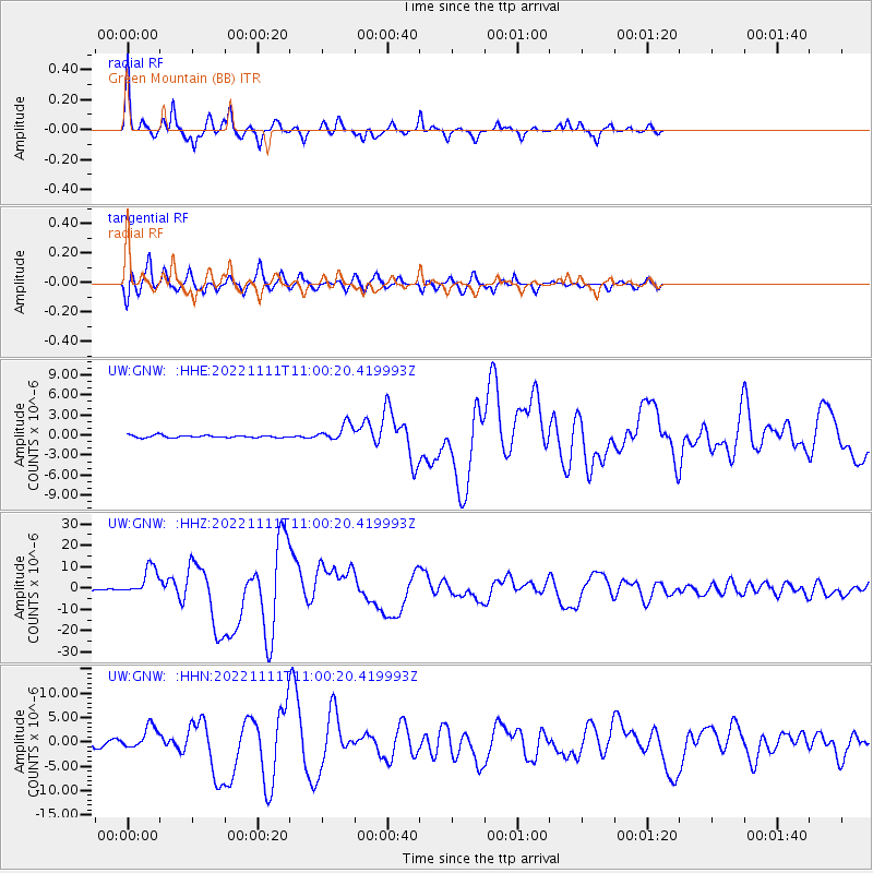
Signal To Noise
| Channel | StoN | STA | LTA |
| UW:GNW: :HHZ:20221111T11:00:20.419993Z | 28.07383 | 6.7083843E-6 | 2.389551E-7 |
| UW:GNW: :HHN:20221111T11:00:20.419993Z | 4.5004873 | 2.3005246E-6 | 5.111723E-7 |
| UW:GNW: :HHE:20221111T11:00:20.419993Z | 7.246676 | 1.2812142E-6 | 1.7680026E-7 |
| Arrivals |
| Ps | 2.3 SECOND |
| PpPs | 7.1 SECOND |
| PsPs/PpSs | 9.4 SECOND |


