You are here: Home > Network List > UW - Pacific Northwest Regional Seismic Network Stations List
> Station LTY Liberty (broad-band) > Earthquake Result Viewer
LTY Liberty (broad-band) - Earthquake Result Viewer
| Earthquake location: |
Tonga Islands Region |
| Earthquake latitude/longitude: |
-19.3/-172.1 |
| Earthquake time(UTC): |
2022/11/11 (315) 10:48:45 GMT |
| Earthquake Depth: |
25 km |
| Earthquake Magnitude: |
7.3 Mww |
| Earthquake Catalog/Contributor: |
NEIC PDE/us |
|
| Network: |
UW Pacific Northwest Regional Seismic Network |
| Station: |
LTY Liberty (broad-band) |
| Lat/Lon: |
47.26 N/120.66 W |
| Elevation: |
970 m |
|
| Distance: |
80.8 deg |
| Az: |
32.656 deg |
| Baz: |
228.425 deg |
| Ray Param: |
0.048019674 |
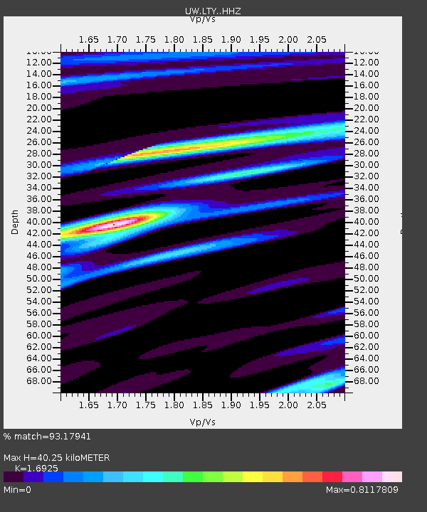
| Estimated Moho Depth: |
40.25 km |
| Estimated Crust Vp/Vs: |
1.69 |
| Assumed Crust Vp: |
6.597 km/s |
| Estimated Crust Vs: |
3.898 km/s |
| Estimated Crust Poisson's Ratio: |
0.23 |
|
| Radial Match: |
93.17941 % |
| Radial Bump: |
281 |
| Transverse Match: |
90.879845 % |
| Transverse Bump: |
383 |
| SOD ConfigId: |
29756493 |
| Insert Time: |
2022-11-25 11:31:24.585 +0000 |
| GWidth: |
2.5 |
| Max Bumps: |
400 |
| Tol: |
0.001 |
|

Signal To Noise
| Channel | StoN | STA | LTA |
| UW:LTY: :HHZ:20221111T11:00:25.089976Z | 25.131565 | 7.154607E-6 | 2.8468608E-7 |
| UW:LTY: :HHN:20221111T11:00:25.089976Z | 5.4506536 | 1.6984585E-6 | 3.116064E-7 |
| UW:LTY: :HHE:20221111T11:00:25.089976Z | 7.904799 | 1.9546376E-6 | 2.4727225E-7 |
| Arrivals |
| Ps | 4.4 SECOND |
| PpPs | 16 SECOND |
| PsPs/PpSs | 20 SECOND |


