You are here: Home > Network List > UW - Pacific Northwest Regional Seismic Network Stations List
> Station SALO Clinton, WA, USA > Earthquake Result Viewer
SALO Clinton, WA, USA - Earthquake Result Viewer
| Earthquake location: |
Tonga Islands Region |
| Earthquake latitude/longitude: |
-19.3/-172.1 |
| Earthquake time(UTC): |
2022/11/11 (315) 10:48:45 GMT |
| Earthquake Depth: |
25 km |
| Earthquake Magnitude: |
7.3 Mww |
| Earthquake Catalog/Contributor: |
NEIC PDE/us |
|
| Network: |
UW Pacific Northwest Regional Seismic Network |
| Station: |
SALO Clinton, WA, USA |
| Lat/Lon: |
47.95 N/122.37 W |
| Elevation: |
147 m |
|
| Distance: |
80.4 deg |
| Az: |
31.346 deg |
| Baz: |
226.953 deg |
| Ray Param: |
0.048283774 |
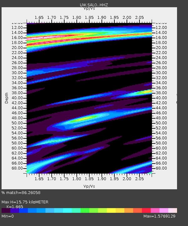
| Estimated Moho Depth: |
15.75 km |
| Estimated Crust Vp/Vs: |
1.66 |
| Assumed Crust Vp: |
6.566 km/s |
| Estimated Crust Vs: |
3.944 km/s |
| Estimated Crust Poisson's Ratio: |
0.22 |
|
| Radial Match: |
86.26058 % |
| Radial Bump: |
336 |
| Transverse Match: |
77.11738 % |
| Transverse Bump: |
400 |
| SOD ConfigId: |
29756493 |
| Insert Time: |
2022-11-25 11:32:07.094 +0000 |
| GWidth: |
2.5 |
| Max Bumps: |
400 |
| Tol: |
0.001 |
|

Signal To Noise
| Channel | StoN | STA | LTA |
| UW:SALO: :HHZ:20221111T11:00:23.039988Z | 19.028214 | 1.099563E-5 | 5.778593E-7 |
| UW:SALO: :HHN:20221111T11:00:23.039988Z | 0.94122964 | 1.7550375E-6 | 1.8646219E-6 |
| UW:SALO: :HHE:20221111T11:00:23.039988Z | 1.0203336 | 1.8493964E-6 | 1.812541E-6 |
| Arrivals |
| Ps | 1.6 SECOND |
| PpPs | 6.2 SECOND |
| PsPs/PpSs | 7.8 SECOND |


