You are here: Home > Network List > UW - Pacific Northwest Regional Seismic Network Stations List
> Station WYNO Wynoochee Dam Area, Olympic National Forest, WA, USA > Earthquake Result Viewer
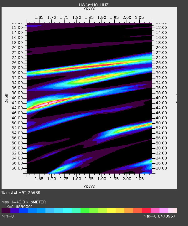
WYNO Wynoochee Dam Area, Olympic National Forest, WA, USA - Earthquake Result Viewer
| Earthquake location: |
Tonga Islands Region |
| Earthquake latitude/longitude: |
-19.3/-172.1 |
| Earthquake time(UTC): |
2022/11/11 (315) 10:48:45 GMT |
| Earthquake Depth: |
25 km |
| Earthquake Magnitude: |
7.3 Mww |
| Earthquake Catalog/Contributor: |
NEIC PDE/us |
|
| Network: |
UW Pacific Northwest Regional Seismic Network |
| Station: |
WYNO Wynoochee Dam Area, Olympic National Forest, WA, USA |
| Lat/Lon: |
47.43 N/123.61 W |
| Elevation: |
935 m |
|
| Distance: |
79.4 deg |
| Az: |
31.141 deg |
| Baz: |
226.003 deg |
| Ray Param: |
0.04894566 |
| Estimated Moho Depth: |
42.0 km |
| Estimated Crust Vp/Vs: |
1.69 |
| Assumed Crust Vp: |
6.566 km/s |
| Estimated Crust Vs: |
3.897 km/s |
| Estimated Crust Poisson's Ratio: |
0.23 |
|
| Radial Match: |
92.25689 % |
| Radial Bump: |
232 |
| Transverse Match: |
80.068245 % |
| Transverse Bump: |
400 |
| SOD ConfigId: |
29756493 |
| Insert Time: |
2022-11-25 11:32:46.179 +0000 |
| GWidth: |
2.5 |
| Max Bumps: |
400 |
| Tol: |
0.001 |
|

Signal To Noise
| Channel | StoN | STA | LTA |
| UW:WYNO: :HHZ:20221111T11:00:17.839976Z | 22.495497 | 6.7309675E-6 | 2.99214E-7 |
| UW:WYNO: :HHN:20221111T11:00:17.839976Z | 7.1259346 | 2.3434504E-6 | 3.288622E-7 |
| UW:WYNO: :HHE:20221111T11:00:17.839976Z | 3.3354688 | 1.630654E-6 | 4.88883E-7 |
| Arrivals |
| Ps | 4.5 SECOND |
| PpPs | 17 SECOND |
| PsPs/PpSs | 21 SECOND |


