You are here: Home > Network List > UW - Pacific Northwest Regional Seismic Network Stations List
> Station OHOH Hoh Rainforest, Olympic National Park, WA, USA > Earthquake Result Viewer
OHOH Hoh Rainforest, Olympic National Park, WA, USA - Earthquake Result Viewer
| Earthquake location: |
Tonga Islands Region |
| Earthquake latitude/longitude: |
-19.3/-172.1 |
| Earthquake time(UTC): |
2022/11/11 (315) 10:48:45 GMT |
| Earthquake Depth: |
25 km |
| Earthquake Magnitude: |
7.3 Mww |
| Earthquake Catalog/Contributor: |
NEIC PDE/us |
|
| Network: |
UW Pacific Northwest Regional Seismic Network |
| Station: |
OHOH Hoh Rainforest, Olympic National Park, WA, USA |
| Lat/Lon: |
47.86 N/123.93 W |
| Elevation: |
179 m |
|
| Distance: |
79.6 deg |
| Az: |
30.677 deg |
| Baz: |
225.683 deg |
| Ray Param: |
0.048846513 |
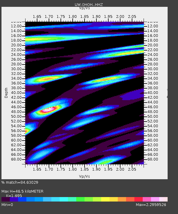
| Estimated Moho Depth: |
46.5 km |
| Estimated Crust Vp/Vs: |
1.70 |
| Assumed Crust Vp: |
6.566 km/s |
| Estimated Crust Vs: |
3.874 km/s |
| Estimated Crust Poisson's Ratio: |
0.23 |
|
| Radial Match: |
84.63029 % |
| Radial Bump: |
400 |
| Transverse Match: |
71.34403 % |
| Transverse Bump: |
400 |
| SOD ConfigId: |
29756493 |
| Insert Time: |
2022-11-25 11:33:54.571 +0000 |
| GWidth: |
2.5 |
| Max Bumps: |
400 |
| Tol: |
0.001 |
|

Signal To Noise
| Channel | StoN | STA | LTA |
| UW:OHOH: :HHZ:20221111T11:00:18.609996Z | 21.919416 | 6.492253E-6 | 2.961873E-7 |
| UW:OHOH: :HHN:20221111T11:00:18.609996Z | 2.9352527 | 1.8832977E-6 | 6.416135E-7 |
| UW:OHOH: :HHE:20221111T11:00:18.609996Z | 2.899624 | 1.5011499E-6 | 5.1770496E-7 |
| Arrivals |
| Ps | 5.1 SECOND |
| PpPs | 18 SECOND |
| PsPs/PpSs | 24 SECOND |


