You are here: Home > Network List > XL17 - McGill Dawson-Septimus Induced Seismicity Study () Stations List
> Station MG03 Z > Earthquake Result Viewer
MG03 Z - Earthquake Result Viewer
| Earthquake location: |
Tonga Islands Region |
| Earthquake latitude/longitude: |
-19.3/-172.1 |
| Earthquake time(UTC): |
2022/11/11 (315) 10:48:45 GMT |
| Earthquake Depth: |
25 km |
| Earthquake Magnitude: |
7.3 Mww |
| Earthquake Catalog/Contributor: |
NEIC PDE/us |
|
| Network: |
XL McGill Dawson-Septimus Induced Seismicity Study () |
| Station: |
MG03 Z |
| Lat/Lon: |
55.91 N/120.44 W |
| Elevation: |
697 m |
|
| Distance: |
86.7 deg |
| Az: |
26.255 deg |
| Baz: |
227.899 deg |
| Ray Param: |
0.04385971 |
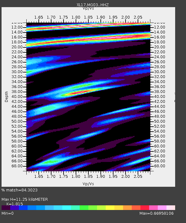
| Estimated Moho Depth: |
11.25 km |
| Estimated Crust Vp/Vs: |
1.82 |
| Assumed Crust Vp: |
6.303 km/s |
| Estimated Crust Vs: |
3.472 km/s |
| Estimated Crust Poisson's Ratio: |
0.28 |
|
| Radial Match: |
84.3023 % |
| Radial Bump: |
400 |
| Transverse Match: |
75.8916 % |
| Transverse Bump: |
400 |
| SOD ConfigId: |
29756493 |
| Insert Time: |
2022-11-25 11:34:48.402 +0000 |
| GWidth: |
2.5 |
| Max Bumps: |
400 |
| Tol: |
0.001 |
|

Signal To Noise
| Channel | StoN | STA | LTA |
| XL:MG03: :HHZ:20221111T11:00:55.140025Z | 6.028127 | 4.832424E-6 | 8.01646E-7 |
| XL:MG03: :HHN:20221111T11:00:55.140025Z | 3.0739286 | 1.9153956E-6 | 6.2310994E-7 |
| XL:MG03: :HHE:20221111T11:00:55.140025Z | 0.64416164 | 6.727449E-7 | 1.0443728E-6 |
| Arrivals |
| Ps | 1.5 SECOND |
| PpPs | 4.9 SECOND |
| PsPs/PpSs | 6.4 SECOND |


