You are here: Home > Network List > XL17 - McGill Dawson-Septimus Induced Seismicity Study () Stations List
> Station MG04 Z > Earthquake Result Viewer
MG04 Z - Earthquake Result Viewer
| Earthquake location: |
Tonga Islands Region |
| Earthquake latitude/longitude: |
-19.3/-172.1 |
| Earthquake time(UTC): |
2022/11/11 (315) 10:48:45 GMT |
| Earthquake Depth: |
25 km |
| Earthquake Magnitude: |
7.3 Mww |
| Earthquake Catalog/Contributor: |
NEIC PDE/us |
|
| Network: |
XL McGill Dawson-Septimus Induced Seismicity Study () |
| Station: |
MG04 Z |
| Lat/Lon: |
55.99 N/120.34 W |
| Elevation: |
682 m |
|
| Distance: |
86.8 deg |
| Az: |
26.235 deg |
| Baz: |
227.983 deg |
| Ray Param: |
0.04378938 |
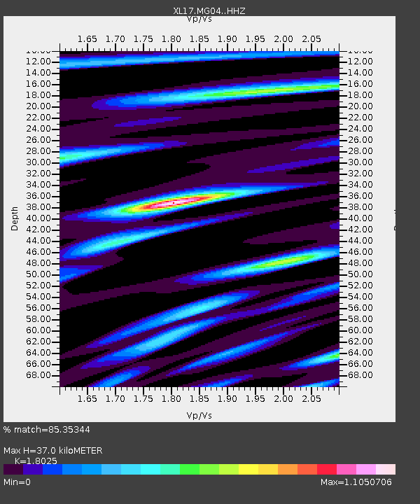
| Estimated Moho Depth: |
37.0 km |
| Estimated Crust Vp/Vs: |
1.80 |
| Assumed Crust Vp: |
6.303 km/s |
| Estimated Crust Vs: |
3.497 km/s |
| Estimated Crust Poisson's Ratio: |
0.28 |
|
| Radial Match: |
85.35344 % |
| Radial Bump: |
400 |
| Transverse Match: |
84.570335 % |
| Transverse Bump: |
400 |
| SOD ConfigId: |
29756493 |
| Insert Time: |
2022-11-25 11:34:50.272 +0000 |
| GWidth: |
2.5 |
| Max Bumps: |
400 |
| Tol: |
0.001 |
|

Signal To Noise
| Channel | StoN | STA | LTA |
| XL:MG04: :HHZ:20221111T11:00:55.609996Z | 14.032966 | 5.86039E-6 | 4.1761592E-7 |
| XL:MG04: :HHN:20221111T11:00:55.609996Z | 4.145062 | 2.1185556E-6 | 5.1110345E-7 |
| XL:MG04: :HHE:20221111T11:00:55.609996Z | 0.82941514 | 6.565547E-7 | 7.9158747E-7 |
| Arrivals |
| Ps | 4.8 SECOND |
| PpPs | 16 SECOND |
| PsPs/PpSs | 21 SECOND |


