You are here: Home > Network List > TA - USArray Transportable Network (new EarthScope stations) Stations List
> Station 431A Sonora, TX, USA > Earthquake Result Viewer
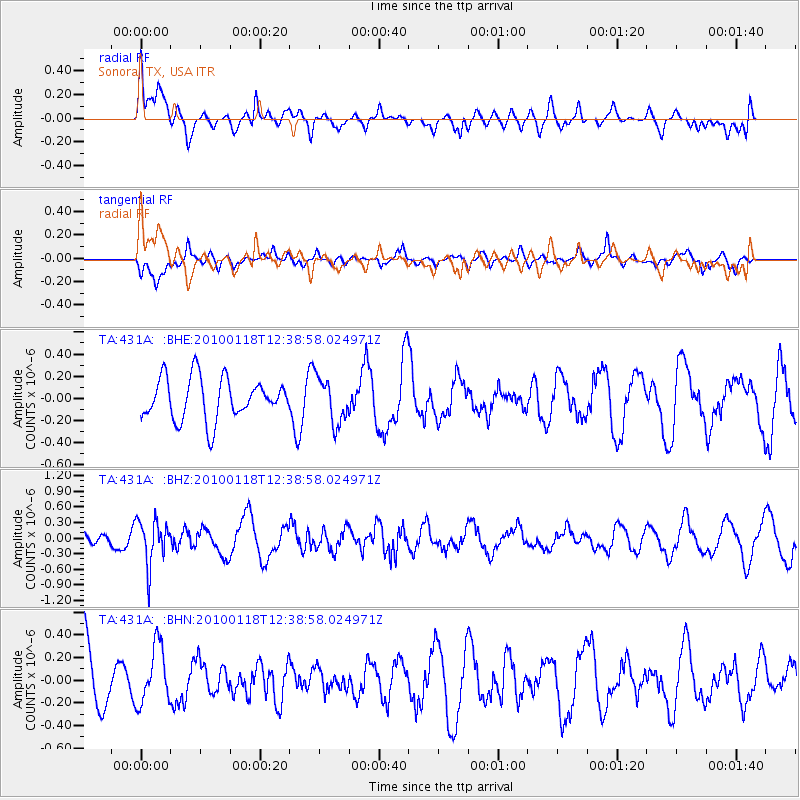
431A Sonora, TX, USA - Earthquake Result Viewer
*The percent match for this event was below the threshold and hence no stack was calculated.
| Earthquake location: |
San Juan Province, Argentina |
| Earthquake latitude/longitude: |
-31.4/-68.6 |
| Earthquake time(UTC): |
2010/01/18 (018) 12:28:34 GMT |
| Earthquake Depth: |
94 km |
| Earthquake Magnitude: |
5.5 MB, 5.4 MW, 5.4 MW |
| Earthquake Catalog/Contributor: |
WHDF/NEIC |
|
| Network: |
TA USArray Transportable Network (new EarthScope stations) |
| Station: |
431A Sonora, TX, USA |
| Lat/Lon: |
30.68 N/100.61 W |
| Elevation: |
700 m |
|
| Distance: |
68.8 deg |
| Az: |
330.667 deg |
| Baz: |
150.891 deg |
| Ray Param: |
$rayparam |
*The percent match for this event was below the threshold and hence was not used in the summary stack. |
|
| Radial Match: |
54.832104 % |
| Radial Bump: |
400 |
| Transverse Match: |
50.386486 % |
| Transverse Bump: |
364 |
| SOD ConfigId: |
296938 |
| Insert Time: |
2010-04-06 21:30:07.511 +0000 |
| GWidth: |
2.5 |
| Max Bumps: |
400 |
| Tol: |
0.001 |
|
Signal To Noise
| Channel | StoN | STA | LTA |
| TA:431A: :BHZ:20100118T12:38:58.024971Z | 3.244681 | 4.2320156E-7 | 1.3042933E-7 |
| TA:431A: :BHN:20100118T12:38:58.024971Z | 1.1049099 | 2.543085E-7 | 2.301622E-7 |
| TA:431A: :BHE:20100118T12:38:58.024971Z | 1.0990796 | 2.0416957E-7 | 1.8576414E-7 |
| Arrivals |
| Ps | |
| PpPs | |
| PsPs/PpSs | |


