You are here: Home > Network List > TA - USArray Transportable Network (new EarthScope stations) Stations List
> Station 632A Uvalde, TX, USA > Earthquake Result Viewer
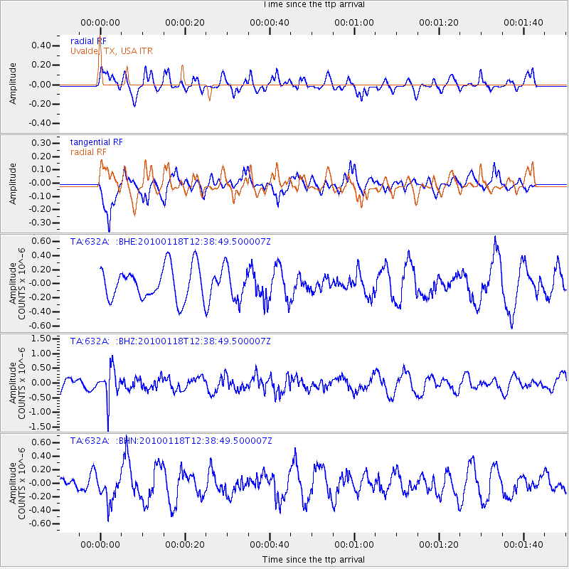
632A Uvalde, TX, USA - Earthquake Result Viewer
*The percent match for this event was below the threshold and hence no stack was calculated.
| Earthquake location: |
San Juan Province, Argentina |
| Earthquake latitude/longitude: |
-31.4/-68.6 |
| Earthquake time(UTC): |
2010/01/18 (018) 12:28:34 GMT |
| Earthquake Depth: |
94 km |
| Earthquake Magnitude: |
5.5 MB, 5.4 MW, 5.4 MW |
| Earthquake Catalog/Contributor: |
WHDF/NEIC |
|
| Network: |
TA USArray Transportable Network (new EarthScope stations) |
| Station: |
632A Uvalde, TX, USA |
| Lat/Lon: |
29.51 N/99.79 W |
| Elevation: |
420 m |
|
| Distance: |
67.4 deg |
| Az: |
330.729 deg |
| Baz: |
151.324 deg |
| Ray Param: |
$rayparam |
*The percent match for this event was below the threshold and hence was not used in the summary stack. |
|
| Radial Match: |
55.23678 % |
| Radial Bump: |
400 |
| Transverse Match: |
63.72078 % |
| Transverse Bump: |
400 |
| SOD ConfigId: |
296938 |
| Insert Time: |
2010-04-06 21:30:24.242 +0000 |
| GWidth: |
2.5 |
| Max Bumps: |
400 |
| Tol: |
0.001 |
|
Signal To Noise
| Channel | StoN | STA | LTA |
| TA:632A: :BHZ:20100118T12:38:49.500007Z | 1.8831785 | 5.0893055E-7 | 2.7025084E-7 |
| TA:632A: :BHN:20100118T12:38:49.500007Z | 1.0935882 | 2.0624037E-7 | 1.8859052E-7 |
| TA:632A: :BHE:20100118T12:38:49.500007Z | 1.0201987 | 2.3600806E-7 | 2.3133538E-7 |
| Arrivals |
| Ps | |
| PpPs | |
| PsPs/PpSs | |


