You are here: Home > Network List > TA - USArray Transportable Network (new EarthScope stations) Stations List
> Station 332A Millersview, TX, USA > Earthquake Result Viewer
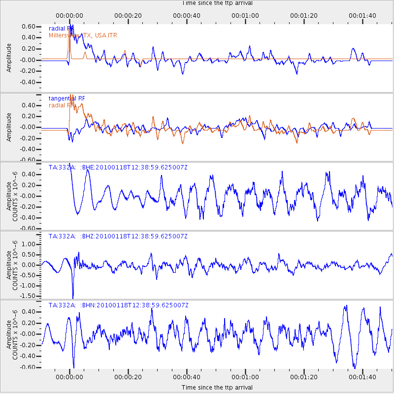
332A Millersview, TX, USA - Earthquake Result Viewer
*The percent match for this event was below the threshold and hence no stack was calculated.
| Earthquake location: |
San Juan Province, Argentina |
| Earthquake latitude/longitude: |
-31.4/-68.6 |
| Earthquake time(UTC): |
2010/01/18 (018) 12:28:34 GMT |
| Earthquake Depth: |
94 km |
| Earthquake Magnitude: |
5.5 MB, 5.4 MW, 5.4 MW |
| Earthquake Catalog/Contributor: |
WHDF/NEIC |
|
| Network: |
TA USArray Transportable Network (new EarthScope stations) |
| Station: |
332A Millersview, TX, USA |
| Lat/Lon: |
31.38 N/99.74 W |
| Elevation: |
513 m |
|
| Distance: |
69.0 deg |
| Az: |
331.725 deg |
| Baz: |
151.716 deg |
| Ray Param: |
$rayparam |
*The percent match for this event was below the threshold and hence was not used in the summary stack. |
|
| Radial Match: |
65.03634 % |
| Radial Bump: |
400 |
| Transverse Match: |
40.16871 % |
| Transverse Bump: |
400 |
| SOD ConfigId: |
296938 |
| Insert Time: |
2010-04-06 21:30:42.257 +0000 |
| GWidth: |
2.5 |
| Max Bumps: |
400 |
| Tol: |
0.001 |
|
Signal To Noise
| Channel | StoN | STA | LTA |
| TA:332A: :BHZ:20100118T12:38:59.625007Z | 2.6560953 | 4.5700924E-7 | 1.7206055E-7 |
| TA:332A: :BHN:20100118T12:38:59.625007Z | 0.87035304 | 2.5840703E-7 | 2.968991E-7 |
| TA:332A: :BHE:20100118T12:38:59.625007Z | 0.8213626 | 1.6520482E-7 | 2.0113508E-7 |
| Arrivals |
| Ps | |
| PpPs | |
| PsPs/PpSs | |


