You are here: Home > Network List > TA - USArray Transportable Network (new EarthScope stations) Stations List
> Station N29A Votaw Ranch, Wellfleet, NE, USA > Earthquake Result Viewer
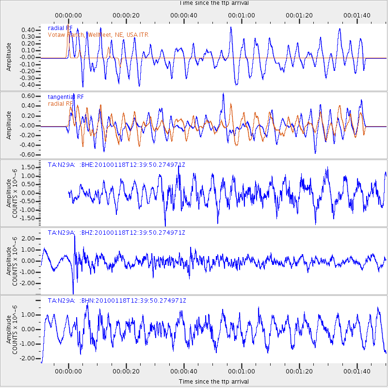
N29A Votaw Ranch, Wellfleet, NE, USA - Earthquake Result Viewer
*The percent match for this event was below the threshold and hence no stack was calculated.
| Earthquake location: |
San Juan Province, Argentina |
| Earthquake latitude/longitude: |
-31.4/-68.6 |
| Earthquake time(UTC): |
2010/01/18 (018) 12:28:34 GMT |
| Earthquake Depth: |
94 km |
| Earthquake Magnitude: |
5.5 MB, 5.4 MW, 5.4 MW |
| Earthquake Catalog/Contributor: |
WHDF/NEIC |
|
| Network: |
TA USArray Transportable Network (new EarthScope stations) |
| Station: |
N29A Votaw Ranch, Wellfleet, NE, USA |
| Lat/Lon: |
40.82 N/100.63 W |
| Elevation: |
897 m |
|
| Distance: |
77.7 deg |
| Az: |
335.671 deg |
| Baz: |
152.33 deg |
| Ray Param: |
$rayparam |
*The percent match for this event was below the threshold and hence was not used in the summary stack. |
|
| Radial Match: |
59.630802 % |
| Radial Bump: |
400 |
| Transverse Match: |
74.40157 % |
| Transverse Bump: |
400 |
| SOD ConfigId: |
296938 |
| Insert Time: |
2010-04-06 21:32:34.013 +0000 |
| GWidth: |
2.5 |
| Max Bumps: |
400 |
| Tol: |
0.001 |
|
Signal To Noise
| Channel | StoN | STA | LTA |
| TA:N29A: :BHZ:20100118T12:39:50.274971Z | 2.2840528 | 9.3186844E-7 | 4.07989E-7 |
| TA:N29A: :BHN:20100118T12:39:50.274971Z | 0.89355326 | 7.089597E-7 | 7.9341623E-7 |
| TA:N29A: :BHE:20100118T12:39:50.274971Z | 1.8477337 | 7.3355903E-7 | 3.9700473E-7 |
| Arrivals |
| Ps | |
| PpPs | |
| PsPs/PpSs | |


