You are here: Home > Network List > TA - USArray Transportable Network (new EarthScope stations) Stations List
> Station N28A Pribbeno Ranch, Imperial, NE, USA > Earthquake Result Viewer
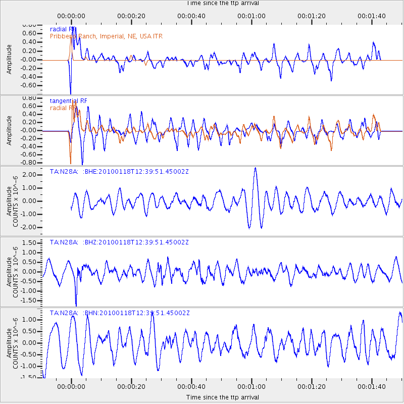
N28A Pribbeno Ranch, Imperial, NE, USA - Earthquake Result Viewer
*The percent match for this event was below the threshold and hence no stack was calculated.
| Earthquake location: |
San Juan Province, Argentina |
| Earthquake latitude/longitude: |
-31.4/-68.6 |
| Earthquake time(UTC): |
2010/01/18 (018) 12:28:34 GMT |
| Earthquake Depth: |
94 km |
| Earthquake Magnitude: |
5.5 MB, 5.4 MW, 5.4 MW |
| Earthquake Catalog/Contributor: |
WHDF/NEIC |
|
| Network: |
TA USArray Transportable Network (new EarthScope stations) |
| Station: |
N28A Pribbeno Ranch, Imperial, NE, USA |
| Lat/Lon: |
40.69 N/101.54 W |
| Elevation: |
1009 m |
|
| Distance: |
77.9 deg |
| Az: |
334.981 deg |
| Baz: |
151.589 deg |
| Ray Param: |
$rayparam |
*The percent match for this event was below the threshold and hence was not used in the summary stack. |
|
| Radial Match: |
59.091053 % |
| Radial Bump: |
400 |
| Transverse Match: |
59.771606 % |
| Transverse Bump: |
400 |
| SOD ConfigId: |
296938 |
| Insert Time: |
2010-04-06 21:32:40.391 +0000 |
| GWidth: |
2.5 |
| Max Bumps: |
400 |
| Tol: |
0.001 |
|
Signal To Noise
| Channel | StoN | STA | LTA |
| TA:N28A: :BHZ:20100118T12:39:51.45002Z | 2.0088136 | 5.6507497E-7 | 2.8129784E-7 |
| TA:N28A: :BHN:20100118T12:39:51.45002Z | 1.0066304 | 8.6705177E-7 | 8.613407E-7 |
| TA:N28A: :BHE:20100118T12:39:51.45002Z | 0.67040145 | 3.4320448E-7 | 5.1193877E-7 |
| Arrivals |
| Ps | |
| PpPs | |
| PsPs/PpSs | |


