You are here: Home > Network List > TA - USArray Transportable Network (new EarthScope stations) Stations List
> Station T24B San Luis, CO, USA > Earthquake Result Viewer
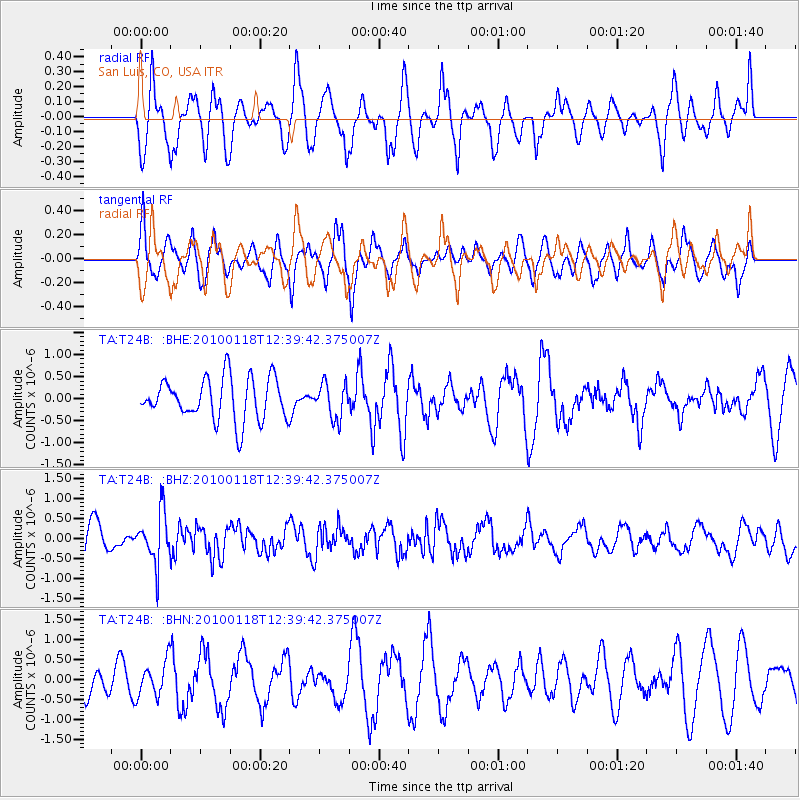
T24B San Luis, CO, USA - Earthquake Result Viewer
*The percent match for this event was below the threshold and hence no stack was calculated.
| Earthquake location: |
San Juan Province, Argentina |
| Earthquake latitude/longitude: |
-31.4/-68.6 |
| Earthquake time(UTC): |
2010/01/18 (018) 12:28:34 GMT |
| Earthquake Depth: |
94 km |
| Earthquake Magnitude: |
5.5 MB, 5.4 MW, 5.4 MW |
| Earthquake Catalog/Contributor: |
WHDF/NEIC |
|
| Network: |
TA USArray Transportable Network (new EarthScope stations) |
| Station: |
T24B San Luis, CO, USA |
| Lat/Lon: |
37.06 N/105.38 W |
| Elevation: |
2625 m |
|
| Distance: |
76.3 deg |
| Az: |
330.457 deg |
| Baz: |
148.175 deg |
| Ray Param: |
$rayparam |
*The percent match for this event was below the threshold and hence was not used in the summary stack. |
|
| Radial Match: |
60.740467 % |
| Radial Bump: |
400 |
| Transverse Match: |
61.84162 % |
| Transverse Bump: |
400 |
| SOD ConfigId: |
296938 |
| Insert Time: |
2010-04-06 21:34:04.954 +0000 |
| GWidth: |
2.5 |
| Max Bumps: |
400 |
| Tol: |
0.001 |
|
Signal To Noise
| Channel | StoN | STA | LTA |
| TA:T24B: :BHZ:20100118T12:39:42.375007Z | 1.5457041 | 6.321503E-7 | 4.089724E-7 |
| TA:T24B: :BHN:20100118T12:39:42.375007Z | 1.1972803 | 4.3468702E-7 | 3.6306204E-7 |
| TA:T24B: :BHE:20100118T12:39:42.375007Z | 0.83148277 | 3.964809E-7 | 4.76836E-7 |
| Arrivals |
| Ps | |
| PpPs | |
| PsPs/PpSs | |


