You are here: Home > Network List > CB - China National Seismic Network Stations List
> Station GZH Guangzhou,Guangdong Province > Earthquake Result Viewer
GZH Guangzhou,Guangdong Province - Earthquake Result Viewer
| Earthquake location: |
Northern Xinjiang, China |
| Earthquake latitude/longitude: |
44.3/82.8 |
| Earthquake time(UTC): |
2017/08/08 (220) 23:27:53 GMT |
| Earthquake Depth: |
20 km |
| Earthquake Magnitude: |
6.3 Mww |
| Earthquake Catalog/Contributor: |
NEIC PDE/us |
|
| Network: |
CB China National Seismic Network |
| Station: |
GZH Guangzhou,Guangdong Province |
| Lat/Lon: |
23.65 N/113.65 E |
| Elevation: |
65 m |
|
| Distance: |
32.5 deg |
| Az: |
119.127 deg |
| Baz: |
316.846 deg |
| Ray Param: |
0.078592226 |
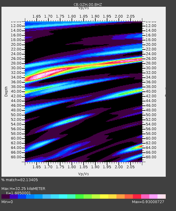
| Estimated Moho Depth: |
32.25 km |
| Estimated Crust Vp/Vs: |
1.69 |
| Assumed Crust Vp: |
6.276 km/s |
| Estimated Crust Vs: |
3.725 km/s |
| Estimated Crust Poisson's Ratio: |
0.23 |
|
| Radial Match: |
82.13405 % |
| Radial Bump: |
298 |
| Transverse Match: |
64.17904 % |
| Transverse Bump: |
400 |
| SOD ConfigId: |
2973751 |
| Insert Time: |
2018-10-08 20:46:14.075 +0000 |
| GWidth: |
2.5 |
| Max Bumps: |
400 |
| Tol: |
0.001 |
|

Signal To Noise
| Channel | StoN | STA | LTA |
| CB:GZH:00:BHZ:20170808T23:33:52.010013Z | 4.8836527 | 1.1756808E-6 | 2.4073802E-7 |
| CB:GZH:00:BHN:20170808T23:33:52.010013Z | 3.9072983 | 5.983021E-7 | 1.5312425E-7 |
| CB:GZH:00:BHE:20170808T23:33:52.010013Z | 3.7793274 | 5.5699815E-7 | 1.4738023E-7 |
| Arrivals |
| Ps | 3.8 SECOND |
| PpPs | 13 SECOND |
| PsPs/PpSs | 17 SECOND |


