You are here: Home > Network List > UW - Pacific Northwest Regional Seismic Network Stations List
> Station UMAT Pilot Rock, OR, USA > Earthquake Result Viewer
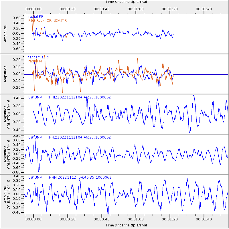
UMAT Pilot Rock, OR, USA - Earthquake Result Viewer
*The percent match for this event was below the threshold and hence no stack was calculated.
| Earthquake location: |
Guatemala |
| Earthquake latitude/longitude: |
14.1/-90.8 |
| Earthquake time(UTC): |
2022/11/12 (316) 04:39:47 GMT |
| Earthquake Depth: |
100 km |
| Earthquake Magnitude: |
5.8 mww |
| Earthquake Catalog/Contributor: |
NEIC PDE/us |
|
| Network: |
UW Pacific Northwest Regional Seismic Network |
| Station: |
UMAT Pilot Rock, OR, USA |
| Lat/Lon: |
45.29 N/118.96 W |
| Elevation: |
1318 m |
|
| Distance: |
39.2 deg |
| Az: |
328.142 deg |
| Baz: |
133.496 deg |
| Ray Param: |
$rayparam |
*The percent match for this event was below the threshold and hence was not used in the summary stack. |
|
| Radial Match: |
60.352795 % |
| Radial Bump: |
400 |
| Transverse Match: |
61.63342 % |
| Transverse Bump: |
373 |
| SOD ConfigId: |
29756493 |
| Insert Time: |
2022-11-26 05:07:31.610 +0000 |
| GWidth: |
2.5 |
| Max Bumps: |
400 |
| Tol: |
0.001 |
|
Signal To Noise
| Channel | StoN | STA | LTA |
| UW:UMAT: :HHZ:20221112T04:46:35.100006Z | 2.9551244 | 4.4280296E-7 | 1.4984242E-7 |
| UW:UMAT: :HHN:20221112T04:46:35.100006Z | 1.3603072 | 1.3158557E-7 | 9.673224E-8 |
| UW:UMAT: :HHE:20221112T04:46:35.100006Z | 1.4028097 | 2.113845E-7 | 1.5068652E-7 |
| Arrivals |
| Ps | |
| PpPs | |
| PsPs/PpSs | |


