You are here: Home > Network List > US - United States National Seismic Network Stations List
> Station MSO Missoula, Montana, USA > Earthquake Result Viewer
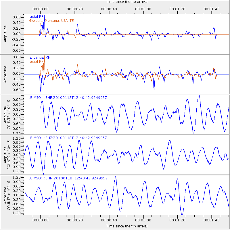
MSO Missoula, Montana, USA - Earthquake Result Viewer
*The percent match for this event was below the threshold and hence no stack was calculated.
| Earthquake location: |
San Juan Province, Argentina |
| Earthquake latitude/longitude: |
-31.4/-68.6 |
| Earthquake time(UTC): |
2010/01/18 (018) 12:28:34 GMT |
| Earthquake Depth: |
94 km |
| Earthquake Magnitude: |
5.5 MB, 5.4 MW, 5.4 MW |
| Earthquake Catalog/Contributor: |
WHDF/NEIC |
|
| Network: |
US United States National Seismic Network |
| Station: |
MSO Missoula, Montana, USA |
| Lat/Lon: |
46.83 N/113.94 W |
| Elevation: |
1264 m |
|
| Distance: |
87.9 deg |
| Az: |
330.743 deg |
| Baz: |
142.487 deg |
| Ray Param: |
$rayparam |
*The percent match for this event was below the threshold and hence was not used in the summary stack. |
|
| Radial Match: |
70.86965 % |
| Radial Bump: |
360 |
| Transverse Match: |
74.67496 % |
| Transverse Bump: |
327 |
| SOD ConfigId: |
296938 |
| Insert Time: |
2010-04-06 21:38:11.422 +0000 |
| GWidth: |
2.5 |
| Max Bumps: |
400 |
| Tol: |
0.001 |
|
Signal To Noise
| Channel | StoN | STA | LTA |
| US:MSO: :BHZ:20100118T12:40:42.924995Z | 1.6535316 | 7.9867164E-7 | 4.830096E-7 |
| US:MSO: :BHN:20100118T12:40:42.924995Z | 0.5413653 | 3.2201362E-7 | 5.948176E-7 |
| US:MSO: :BHE:20100118T12:40:42.924995Z | 0.81513554 | 3.7789684E-7 | 4.636E-7 |
| Arrivals |
| Ps | |
| PpPs | |
| PsPs/PpSs | |


