You are here: Home > Network List > AZ - ANZA Regional Network Stations List
> Station SMER AZ.SMER > Earthquake Result Viewer
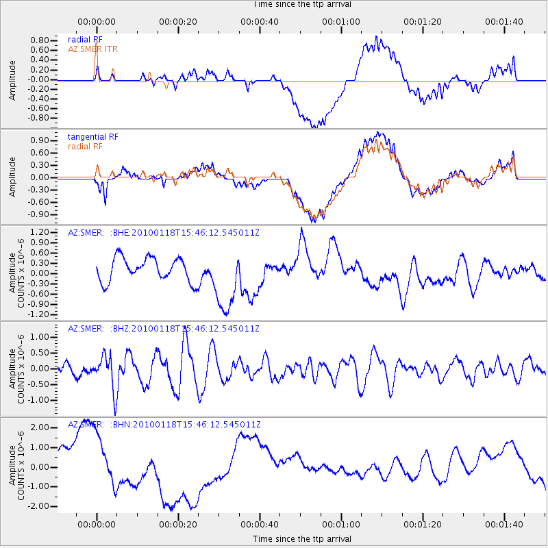
SMER AZ.SMER - Earthquake Result Viewer
*The percent match for this event was below the threshold and hence no stack was calculated.
| Earthquake location: |
Near Coast Of Guatemala |
| Earthquake latitude/longitude: |
13.7/-90.1 |
| Earthquake time(UTC): |
2010/01/18 (018) 15:40:26 GMT |
| Earthquake Depth: |
55 km |
| Earthquake Magnitude: |
5.9 MW, 5.4 MB, 5.8 MW |
| Earthquake Catalog/Contributor: |
WHDF/NEIC |
|
| Network: |
AZ ANZA Regional Network |
| Station: |
SMER AZ.SMER |
| Lat/Lon: |
33.46 N/117.17 W |
| Elevation: |
355 m |
|
| Distance: |
31.5 deg |
| Az: |
313.264 deg |
| Baz: |
122.167 deg |
| Ray Param: |
$rayparam |
*The percent match for this event was below the threshold and hence was not used in the summary stack. |
|
| Radial Match: |
36.15156 % |
| Radial Bump: |
400 |
| Transverse Match: |
40.590157 % |
| Transverse Bump: |
400 |
| SOD ConfigId: |
296938 |
| Insert Time: |
2010-04-06 21:40:23.515 +0000 |
| GWidth: |
2.5 |
| Max Bumps: |
400 |
| Tol: |
0.001 |
|
Signal To Noise
| Channel | StoN | STA | LTA |
| AZ:SMER: :BHZ:20100118T15:46:12.545011Z | 3.1487842 | 5.575465E-7 | 1.7706725E-7 |
| AZ:SMER: :BHN:20100118T15:46:12.545011Z | 1.7788694 | 1.1909742E-6 | 6.695119E-7 |
| AZ:SMER: :BHE:20100118T15:46:12.545011Z | 2.830279 | 9.72358E-7 | 3.4355546E-7 |
| Arrivals |
| Ps | |
| PpPs | |
| PsPs/PpSs | |


