You are here: Home > Network List > AV - Alaska Volcano Observatory Stations List
> Station SPCP Crater Peak Broadband, Mount Spurr, Alaska > Earthquake Result Viewer
SPCP Crater Peak Broadband, Mount Spurr, Alaska - Earthquake Result Viewer
| Earthquake location: |
Fiji Islands Region |
| Earthquake latitude/longitude: |
-20.1/-178.4 |
| Earthquake time(UTC): |
2022/11/12 (316) 07:09:14 GMT |
| Earthquake Depth: |
587 km |
| Earthquake Magnitude: |
7.0 mww |
| Earthquake Catalog/Contributor: |
NEIC PDE/us |
|
| Network: |
AV Alaska Volcano Observatory |
| Station: |
SPCP Crater Peak Broadband, Mount Spurr, Alaska |
| Lat/Lon: |
61.27 N/152.15 W |
| Elevation: |
1616 m |
|
| Distance: |
83.8 deg |
| Az: |
12.396 deg |
| Baz: |
204.675 deg |
| Ray Param: |
0.044207133 |
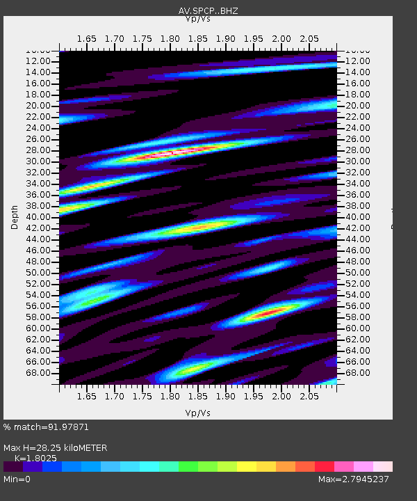
| Estimated Moho Depth: |
28.25 km |
| Estimated Crust Vp/Vs: |
1.80 |
| Assumed Crust Vp: |
6.566 km/s |
| Estimated Crust Vs: |
3.643 km/s |
| Estimated Crust Poisson's Ratio: |
0.28 |
|
| Radial Match: |
91.97871 % |
| Radial Bump: |
400 |
| Transverse Match: |
88.92581 % |
| Transverse Bump: |
400 |
| SOD ConfigId: |
29756493 |
| Insert Time: |
2022-11-26 07:18:39.298 +0000 |
| GWidth: |
2.5 |
| Max Bumps: |
400 |
| Tol: |
0.001 |
|

Signal To Noise
| Channel | StoN | STA | LTA |
| AV:SPCP: :BHZ:20221112T07:20:11.228007Z | 39.747627 | 1.8495606E-5 | 4.6532605E-7 |
| AV:SPCP: :BHN:20221112T07:20:11.228007Z | 23.81446 | 1.5828478E-5 | 6.6465833E-7 |
| AV:SPCP: :BHE:20221112T07:20:11.228007Z | 8.275151 | 6.7391547E-6 | 8.1438446E-7 |
| Arrivals |
| Ps | 3.5 SECOND |
| PpPs | 12 SECOND |
| PsPs/PpSs | 15 SECOND |


