You are here: Home > Network List > CB - China National Seismic Network Stations List
> Station DL2 Dalian,Liaoning Province > Earthquake Result Viewer
DL2 Dalian,Liaoning Province - Earthquake Result Viewer
| Earthquake location: |
Southern Sumatra, Indonesia |
| Earthquake latitude/longitude: |
-3.8/101.6 |
| Earthquake time(UTC): |
2017/08/13 (225) 03:08:11 GMT |
| Earthquake Depth: |
36 km |
| Earthquake Magnitude: |
6.4 Mww |
| Earthquake Catalog/Contributor: |
NEIC PDE/us |
|
| Network: |
CB China National Seismic Network |
| Station: |
DL2 Dalian,Liaoning Province |
| Lat/Lon: |
38.91 N/121.63 E |
| Elevation: |
65 m |
|
| Distance: |
46.3 deg |
| Az: |
21.675 deg |
| Baz: |
208.187 deg |
| Ray Param: |
0.07063164 |
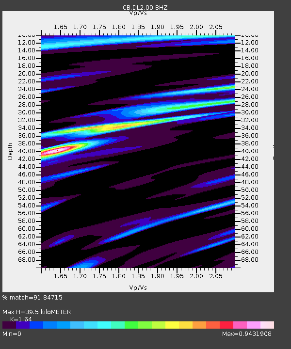
| Estimated Moho Depth: |
39.5 km |
| Estimated Crust Vp/Vs: |
1.64 |
| Assumed Crust Vp: |
6.134 km/s |
| Estimated Crust Vs: |
3.74 km/s |
| Estimated Crust Poisson's Ratio: |
0.20 |
|
| Radial Match: |
91.84715 % |
| Radial Bump: |
305 |
| Transverse Match: |
74.03698 % |
| Transverse Bump: |
400 |
| SOD ConfigId: |
2973751 |
| Insert Time: |
2018-10-08 21:00:24.845 +0000 |
| GWidth: |
2.5 |
| Max Bumps: |
400 |
| Tol: |
0.001 |
|

Signal To Noise
| Channel | StoN | STA | LTA |
| CB:DL2:00:BHZ:20170813T03:16:02.799996Z | 31.57576 | 6.2743934E-6 | 1.9870919E-7 |
| CB:DL2:00:BHN:20170813T03:16:02.799996Z | 17.204601 | 3.2258297E-6 | 1.8749809E-7 |
| CB:DL2:00:BHE:20170813T03:16:02.799996Z | 7.362463 | 1.4456723E-6 | 1.9635716E-7 |
| Arrivals |
| Ps | 4.4 SECOND |
| PpPs | 16 SECOND |
| PsPs/PpSs | 20 SECOND |


