You are here: Home > Network List > BK - Berkeley Digital Seismograph Network Stations List
> Station MCCM Marconi Conference Center, Marshall, CA, USA > Earthquake Result Viewer
MCCM Marconi Conference Center, Marshall, CA, USA - Earthquake Result Viewer
| Earthquake location: |
Fiji Islands Region |
| Earthquake latitude/longitude: |
-20.1/-178.4 |
| Earthquake time(UTC): |
2022/11/12 (316) 07:09:14 GMT |
| Earthquake Depth: |
587 km |
| Earthquake Magnitude: |
7.0 mww |
| Earthquake Catalog/Contributor: |
NEIC PDE/us |
|
| Network: |
BK Berkeley Digital Seismograph Network |
| Station: |
MCCM Marconi Conference Center, Marshall, CA, USA |
| Lat/Lon: |
38.14 N/122.88 W |
| Elevation: |
-7.7 m |
|
| Distance: |
77.9 deg |
| Az: |
41.637 deg |
| Baz: |
232.363 deg |
| Ray Param: |
0.048163895 |
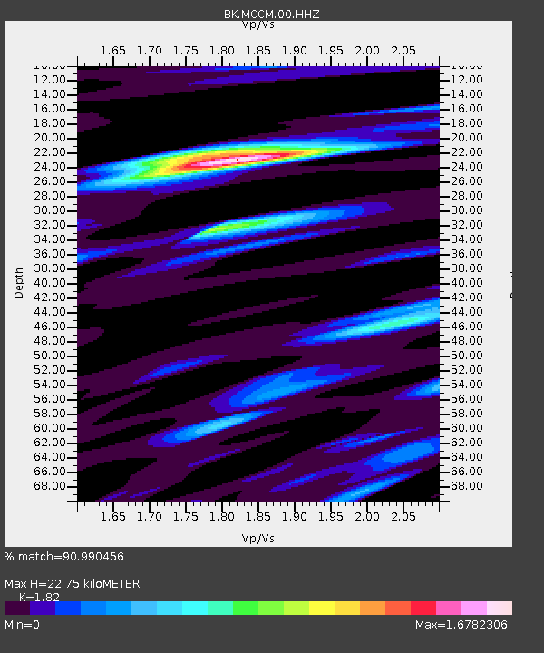
| Estimated Moho Depth: |
22.75 km |
| Estimated Crust Vp/Vs: |
1.82 |
| Assumed Crust Vp: |
6.472 km/s |
| Estimated Crust Vs: |
3.556 km/s |
| Estimated Crust Poisson's Ratio: |
0.28 |
|
| Radial Match: |
90.990456 % |
| Radial Bump: |
400 |
| Transverse Match: |
85.90627 % |
| Transverse Bump: |
400 |
| SOD ConfigId: |
29756493 |
| Insert Time: |
2022-11-26 07:20:25.447 +0000 |
| GWidth: |
2.5 |
| Max Bumps: |
400 |
| Tol: |
0.001 |
|
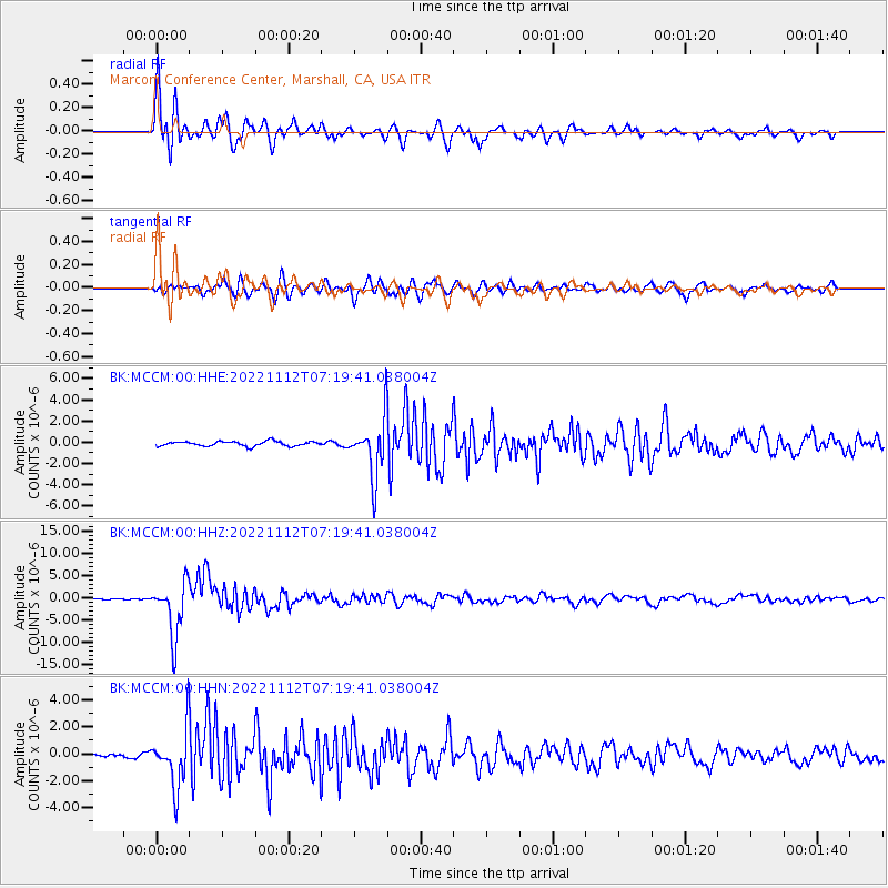
Signal To Noise
| Channel | StoN | STA | LTA |
| BK:MCCM:00:HHZ:20221112T07:19:41.038004Z | 29.943977 | 6.132979E-6 | 2.0481511E-7 |
| BK:MCCM:00:HHN:20221112T07:19:41.038004Z | 12.742409 | 2.0834323E-6 | 1.635038E-7 |
| BK:MCCM:00:HHE:20221112T07:19:41.038004Z | 12.444058 | 2.7008964E-6 | 2.1704305E-7 |
| Arrivals |
| Ps | 3.0 SECOND |
| PpPs | 9.6 SECOND |
| PsPs/PpSs | 13 SECOND |


