You are here: Home > Network List > TA - USArray Transportable Network (new EarthScope stations) Stations List
> Station E21A Keefer Ranch, Vananda, MT, USA > Earthquake Result Viewer
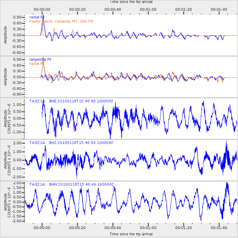
E21A Keefer Ranch, Vananda, MT, USA - Earthquake Result Viewer
*The percent match for this event was below the threshold and hence no stack was calculated.
| Earthquake location: |
Near Coast Of Guatemala |
| Earthquake latitude/longitude: |
13.7/-90.1 |
| Earthquake time(UTC): |
2010/01/18 (018) 15:40:26 GMT |
| Earthquake Depth: |
55 km |
| Earthquake Magnitude: |
5.9 MW, 5.4 MB, 5.8 MW |
| Earthquake Catalog/Contributor: |
WHDF/NEIC |
|
| Network: |
TA USArray Transportable Network (new EarthScope stations) |
| Station: |
E21A Keefer Ranch, Vananda, MT, USA |
| Lat/Lon: |
46.54 N/107.08 W |
| Elevation: |
834 m |
|
| Distance: |
35.7 deg |
| Az: |
339.823 deg |
| Baz: |
150.949 deg |
| Ray Param: |
$rayparam |
*The percent match for this event was below the threshold and hence was not used in the summary stack. |
|
| Radial Match: |
65.02248 % |
| Radial Bump: |
358 |
| Transverse Match: |
48.380013 % |
| Transverse Bump: |
372 |
| SOD ConfigId: |
296938 |
| Insert Time: |
2010-04-06 21:43:56.357 +0000 |
| GWidth: |
2.5 |
| Max Bumps: |
400 |
| Tol: |
0.001 |
|
Signal To Noise
| Channel | StoN | STA | LTA |
| TA:E21A: :BHZ:20100118T15:46:49.100004Z | 2.505407 | 7.816654E-7 | 3.1199136E-7 |
| TA:E21A: :BHN:20100118T15:46:49.100004Z | 0.95290226 | 5.7916515E-7 | 6.0779075E-7 |
| TA:E21A: :BHE:20100118T15:46:49.100004Z | 0.60536075 | 3.1653732E-7 | 5.228904E-7 |
| Arrivals |
| Ps | |
| PpPs | |
| PsPs/PpSs | |


