You are here: Home > Network List > TA - USArray Transportable Network (new EarthScope stations) Stations List
> Station C22A Vida, MT, USA > Earthquake Result Viewer
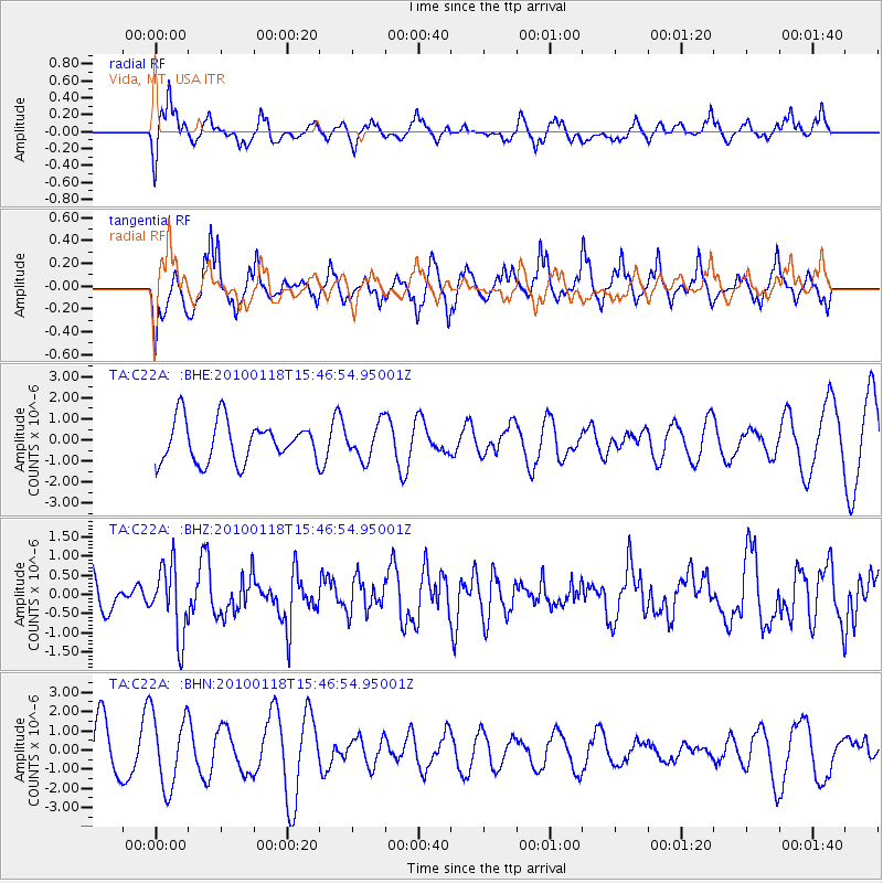
C22A Vida, MT, USA - Earthquake Result Viewer
*The percent match for this event was below the threshold and hence no stack was calculated.
| Earthquake location: |
Near Coast Of Guatemala |
| Earthquake latitude/longitude: |
13.7/-90.1 |
| Earthquake time(UTC): |
2010/01/18 (018) 15:40:26 GMT |
| Earthquake Depth: |
55 km |
| Earthquake Magnitude: |
5.9 MW, 5.4 MB, 5.8 MW |
| Earthquake Catalog/Contributor: |
WHDF/NEIC |
|
| Network: |
TA USArray Transportable Network (new EarthScope stations) |
| Station: |
C22A Vida, MT, USA |
| Lat/Lon: |
47.75 N/105.88 W |
| Elevation: |
745 m |
|
| Distance: |
36.4 deg |
| Az: |
342.001 deg |
| Baz: |
153.581 deg |
| Ray Param: |
$rayparam |
*The percent match for this event was below the threshold and hence was not used in the summary stack. |
|
| Radial Match: |
53.947693 % |
| Radial Bump: |
396 |
| Transverse Match: |
52.205643 % |
| Transverse Bump: |
370 |
| SOD ConfigId: |
296938 |
| Insert Time: |
2010-04-06 21:44:30.005 +0000 |
| GWidth: |
2.5 |
| Max Bumps: |
400 |
| Tol: |
0.001 |
|
Signal To Noise
| Channel | StoN | STA | LTA |
| TA:C22A: :BHZ:20100118T15:46:54.95001Z | 2.1899793 | 9.1876444E-7 | 4.195311E-7 |
| TA:C22A: :BHN:20100118T15:46:54.95001Z | 1.7518334 | 1.9014233E-6 | 1.0853904E-6 |
| TA:C22A: :BHE:20100118T15:46:54.95001Z | 0.8516893 | 8.176245E-7 | 9.600033E-7 |
| Arrivals |
| Ps | |
| PpPs | |
| PsPs/PpSs | |


