You are here: Home > Network List > CC - Cascade Chain Volcano Monitoring Stations List
> Station CLBH Crater Lake, OR, USA > Earthquake Result Viewer
CLBH Crater Lake, OR, USA - Earthquake Result Viewer
| Earthquake location: |
Fiji Islands Region |
| Earthquake latitude/longitude: |
-20.1/-178.4 |
| Earthquake time(UTC): |
2022/11/12 (316) 07:09:14 GMT |
| Earthquake Depth: |
587 km |
| Earthquake Magnitude: |
7.0 mww |
| Earthquake Catalog/Contributor: |
NEIC PDE/us |
|
| Network: |
CC Cascade Chain Volcano Monitoring |
| Station: |
CLBH Crater Lake, OR, USA |
| Lat/Lon: |
42.91 N/122.14 W |
| Elevation: |
2197 m |
|
| Distance: |
81.3 deg |
| Az: |
38.16 deg |
| Baz: |
232.211 deg |
| Ray Param: |
0.045927834 |
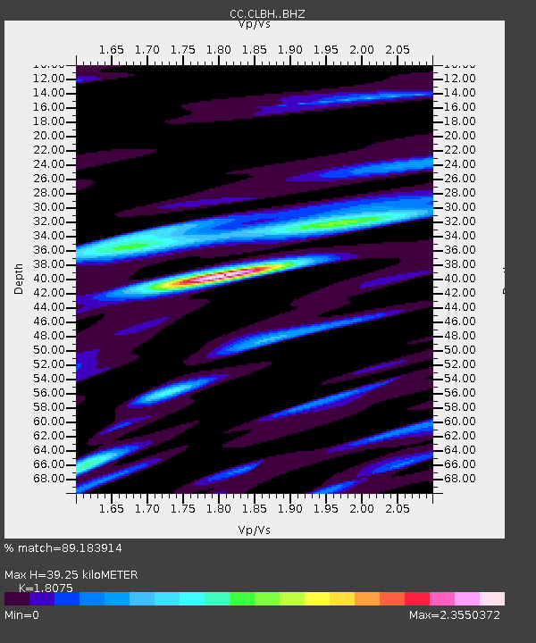
| Estimated Moho Depth: |
39.25 km |
| Estimated Crust Vp/Vs: |
1.81 |
| Assumed Crust Vp: |
6.522 km/s |
| Estimated Crust Vs: |
3.608 km/s |
| Estimated Crust Poisson's Ratio: |
0.28 |
|
| Radial Match: |
89.183914 % |
| Radial Bump: |
400 |
| Transverse Match: |
85.29022 % |
| Transverse Bump: |
400 |
| SOD ConfigId: |
29756493 |
| Insert Time: |
2022-11-26 07:22:14.165 +0000 |
| GWidth: |
2.5 |
| Max Bumps: |
400 |
| Tol: |
0.001 |
|

Signal To Noise
| Channel | StoN | STA | LTA |
| CC:CLBH: :BHZ:20221112T07:19:58.559977Z | 27.915354 | 8.75335E-6 | 3.135676E-7 |
| CC:CLBH: :BHN:20221112T07:19:58.559977Z | 7.6007276 | 3.145405E-6 | 4.1382944E-7 |
| CC:CLBH: :BHE:20221112T07:19:58.559977Z | 15.366671 | 6.662619E-6 | 4.3357596E-7 |
| Arrivals |
| Ps | 5.0 SECOND |
| PpPs | 16 SECOND |
| PsPs/PpSs | 21 SECOND |


