You are here: Home > Network List > TA - USArray Transportable Network (new EarthScope stations) Stations List
> Station E22A Miles City, MT, USA > Earthquake Result Viewer
E22A Miles City, MT, USA - Earthquake Result Viewer
*The percent match for this event was below the threshold and hence no stack was calculated.
| Earthquake location: |
Near Coast Of Guatemala |
| Earthquake latitude/longitude: |
13.7/-90.1 |
| Earthquake time(UTC): |
2010/01/18 (018) 15:40:26 GMT |
| Earthquake Depth: |
55 km |
| Earthquake Magnitude: |
5.9 MW, 5.4 MB, 5.8 MW |
| Earthquake Catalog/Contributor: |
WHDF/NEIC |
|
| Network: |
TA USArray Transportable Network (new EarthScope stations) |
| Station: |
E22A Miles City, MT, USA |
| Lat/Lon: |
46.44 N/105.95 W |
| Elevation: |
784 m |
|
| Distance: |
35.2 deg |
| Az: |
340.923 deg |
| Baz: |
152.659 deg |
| Ray Param: |
$rayparam |
*The percent match for this event was below the threshold and hence was not used in the summary stack. |
|
| Radial Match: |
43.893444 % |
| Radial Bump: |
278 |
| Transverse Match: |
36.399937 % |
| Transverse Bump: |
345 |
| SOD ConfigId: |
296938 |
| Insert Time: |
2010-04-06 21:44:58.931 +0000 |
| GWidth: |
2.5 |
| Max Bumps: |
400 |
| Tol: |
0.001 |
|
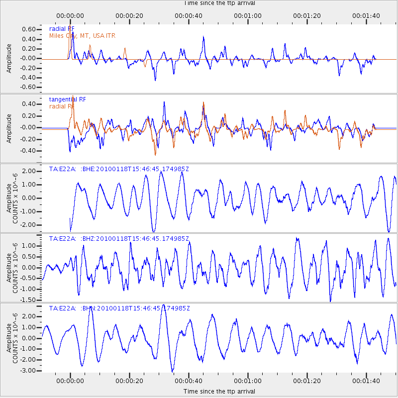
Signal To Noise
| Channel | StoN | STA | LTA |
| TA:E22A: :BHZ:20100118T15:46:45.174985Z | 1.5149881 | 6.067422E-7 | 4.0049306E-7 |
| TA:E22A: :BHN:20100118T15:46:45.174985Z | 2.1503503 | 1.3947791E-6 | 6.4862877E-7 |
| TA:E22A: :BHE:20100118T15:46:45.174985Z | 1.4407729 | 1.2277634E-6 | 8.5215606E-7 |
| Arrivals |
| Ps | |
| PpPs | |
| PsPs/PpSs | |


