You are here: Home > Network List > CC - Cascade Chain Volcano Monitoring Stations List
> Station TIMB Timberline, OR > Earthquake Result Viewer
TIMB Timberline, OR - Earthquake Result Viewer
| Earthquake location: |
Fiji Islands Region |
| Earthquake latitude/longitude: |
-20.1/-178.4 |
| Earthquake time(UTC): |
2022/11/12 (316) 07:09:14 GMT |
| Earthquake Depth: |
587 km |
| Earthquake Magnitude: |
7.0 mww |
| Earthquake Catalog/Contributor: |
NEIC PDE/us |
|
| Network: |
CC Cascade Chain Volcano Monitoring |
| Station: |
TIMB Timberline, OR |
| Lat/Lon: |
45.34 N/121.71 W |
| Elevation: |
1869 m |
|
| Distance: |
83.0 deg |
| Az: |
36.416 deg |
| Baz: |
232.272 deg |
| Ray Param: |
0.04475047 |
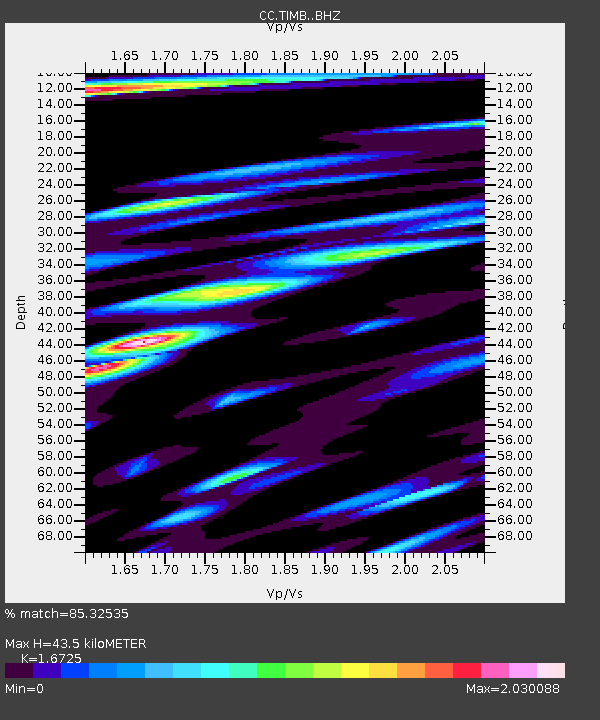
| Estimated Moho Depth: |
43.5 km |
| Estimated Crust Vp/Vs: |
1.67 |
| Assumed Crust Vp: |
6.597 km/s |
| Estimated Crust Vs: |
3.945 km/s |
| Estimated Crust Poisson's Ratio: |
0.22 |
|
| Radial Match: |
85.32535 % |
| Radial Bump: |
400 |
| Transverse Match: |
74.027756 % |
| Transverse Bump: |
400 |
| SOD ConfigId: |
29756493 |
| Insert Time: |
2022-11-26 07:23:10.739 +0000 |
| GWidth: |
2.5 |
| Max Bumps: |
400 |
| Tol: |
0.001 |
|

Signal To Noise
| Channel | StoN | STA | LTA |
| CC:TIMB: :BHZ:20221112T07:20:07.280009Z | 22.123608 | 7.662192E-6 | 3.4633555E-7 |
| CC:TIMB: :BHN:20221112T07:20:07.280009Z | 10.820203 | 4.3687246E-6 | 4.0375625E-7 |
| CC:TIMB: :BHE:20221112T07:20:07.280009Z | 5.971286 | 2.8391437E-6 | 4.7546604E-7 |
| Arrivals |
| Ps | 4.6 SECOND |
| PpPs | 17 SECOND |
| PsPs/PpSs | 22 SECOND |


