You are here: Home > Network List > TA - USArray Transportable Network (new EarthScope stations) Stations List
> Station A26A Wade Farm, Kenmare, ND, USA > Earthquake Result Viewer
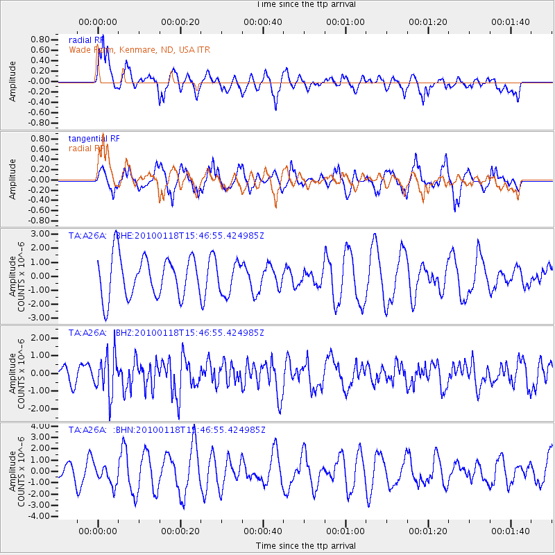
A26A Wade Farm, Kenmare, ND, USA - Earthquake Result Viewer
*The percent match for this event was below the threshold and hence no stack was calculated.
| Earthquake location: |
Near Coast Of Guatemala |
| Earthquake latitude/longitude: |
13.7/-90.1 |
| Earthquake time(UTC): |
2010/01/18 (018) 15:40:26 GMT |
| Earthquake Depth: |
55 km |
| Earthquake Magnitude: |
5.9 MW, 5.4 MB, 5.8 MW |
| Earthquake Catalog/Contributor: |
WHDF/NEIC |
|
| Network: |
TA USArray Transportable Network (new EarthScope stations) |
| Station: |
A26A Wade Farm, Kenmare, ND, USA |
| Lat/Lon: |
48.90 N/102.04 W |
| Elevation: |
570 m |
|
| Distance: |
36.4 deg |
| Az: |
346.743 deg |
| Baz: |
160.264 deg |
| Ray Param: |
$rayparam |
*The percent match for this event was below the threshold and hence was not used in the summary stack. |
|
| Radial Match: |
56.162704 % |
| Radial Bump: |
377 |
| Transverse Match: |
60.269737 % |
| Transverse Bump: |
335 |
| SOD ConfigId: |
296938 |
| Insert Time: |
2010-04-06 21:45:47.639 +0000 |
| GWidth: |
2.5 |
| Max Bumps: |
400 |
| Tol: |
0.001 |
|
Signal To Noise
| Channel | StoN | STA | LTA |
| TA:A26A: :BHZ:20100118T15:46:55.424985Z | 3.514766 | 1.1511529E-6 | 3.2751907E-7 |
| TA:A26A: :BHN:20100118T15:46:55.424985Z | 0.8357663 | 8.804844E-7 | 1.0535055E-6 |
| TA:A26A: :BHE:20100118T15:46:55.424985Z | 0.76274675 | 1.1167866E-6 | 1.4641644E-6 |
| Arrivals |
| Ps | |
| PpPs | |
| PsPs/PpSs | |


