You are here: Home > Network List > CB - China National Seismic Network Stations List
> Station XLT Xilinhaote,Neimeng Province > Earthquake Result Viewer
XLT Xilinhaote,Neimeng Province - Earthquake Result Viewer
| Earthquake location: |
Southern Sumatra, Indonesia |
| Earthquake latitude/longitude: |
-3.8/101.6 |
| Earthquake time(UTC): |
2017/08/13 (225) 03:08:11 GMT |
| Earthquake Depth: |
36 km |
| Earthquake Magnitude: |
6.4 Mww |
| Earthquake Catalog/Contributor: |
NEIC PDE/us |
|
| Network: |
CB China National Seismic Network |
| Station: |
XLT Xilinhaote,Neimeng Province |
| Lat/Lon: |
43.90 N/116.08 E |
| Elevation: |
1030 m |
|
| Distance: |
49.2 deg |
| Az: |
13.806 deg |
| Baz: |
199.233 deg |
| Ray Param: |
0.0687592 |
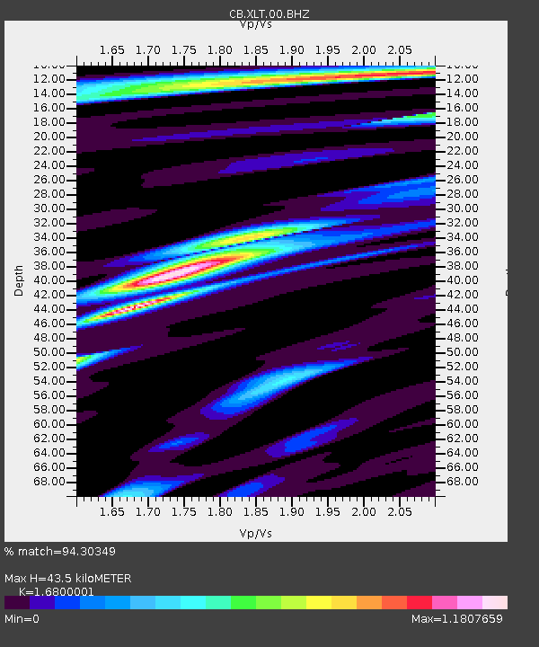
| Estimated Moho Depth: |
43.5 km |
| Estimated Crust Vp/Vs: |
1.68 |
| Assumed Crust Vp: |
6.459 km/s |
| Estimated Crust Vs: |
3.845 km/s |
| Estimated Crust Poisson's Ratio: |
0.23 |
|
| Radial Match: |
94.30349 % |
| Radial Bump: |
400 |
| Transverse Match: |
79.99017 % |
| Transverse Bump: |
400 |
| SOD ConfigId: |
2973751 |
| Insert Time: |
2018-10-08 21:00:44.046 +0000 |
| GWidth: |
2.5 |
| Max Bumps: |
400 |
| Tol: |
0.001 |
|

Signal To Noise
| Channel | StoN | STA | LTA |
| CB:XLT:00:BHZ:20170813T03:16:25.180001Z | 94.66885 | 5.251536E-6 | 5.5472693E-8 |
| CB:XLT:00:BHN:20170813T03:16:25.180001Z | 51.754433 | 2.7169356E-6 | 5.2496674E-8 |
| CB:XLT:00:BHE:20170813T03:16:25.180001Z | 22.488674 | 1.0815628E-6 | 4.8093668E-8 |
| Arrivals |
| Ps | 4.9 SECOND |
| PpPs | 17 SECOND |
| PsPs/PpSs | 22 SECOND |


