You are here: Home > Network List > TA - USArray Transportable Network (new EarthScope stations) Stations List
> Station I29A Vivian, Onida, SD, USA > Earthquake Result Viewer
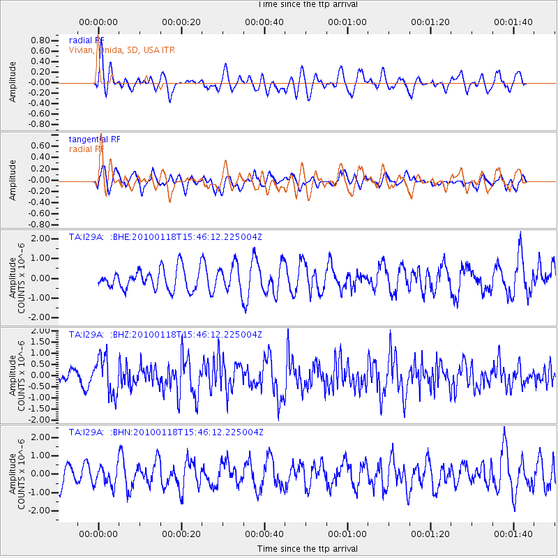
I29A Vivian, Onida, SD, USA - Earthquake Result Viewer
*The percent match for this event was below the threshold and hence no stack was calculated.
| Earthquake location: |
Near Coast Of Guatemala |
| Earthquake latitude/longitude: |
13.7/-90.1 |
| Earthquake time(UTC): |
2010/01/18 (018) 15:40:26 GMT |
| Earthquake Depth: |
55 km |
| Earthquake Magnitude: |
5.9 MW, 5.4 MB, 5.8 MW |
| Earthquake Catalog/Contributor: |
WHDF/NEIC |
|
| Network: |
TA USArray Transportable Network (new EarthScope stations) |
| Station: |
I29A Vivian, Onida, SD, USA |
| Lat/Lon: |
44.02 N/100.30 W |
| Elevation: |
592 m |
|
| Distance: |
31.4 deg |
| Az: |
345.856 deg |
| Baz: |
160.781 deg |
| Ray Param: |
$rayparam |
*The percent match for this event was below the threshold and hence was not used in the summary stack. |
|
| Radial Match: |
50.2137 % |
| Radial Bump: |
400 |
| Transverse Match: |
57.38023 % |
| Transverse Bump: |
400 |
| SOD ConfigId: |
296938 |
| Insert Time: |
2010-04-06 21:46:49.946 +0000 |
| GWidth: |
2.5 |
| Max Bumps: |
400 |
| Tol: |
0.001 |
|
Signal To Noise
| Channel | StoN | STA | LTA |
| TA:I29A: :BHZ:20100118T15:46:12.225004Z | 2.9302087 | 8.496178E-7 | 2.899513E-7 |
| TA:I29A: :BHN:20100118T15:46:12.225004Z | 0.69870335 | 5.183328E-7 | 7.4184953E-7 |
| TA:I29A: :BHE:20100118T15:46:12.225004Z | 1.343723 | 6.9460475E-7 | 5.1692547E-7 |
| Arrivals |
| Ps | |
| PpPs | |
| PsPs/PpSs | |


