You are here: Home > Network List > AZ - ANZA Regional Network Stations List
> Station SMER AZ.SMER > Earthquake Result Viewer
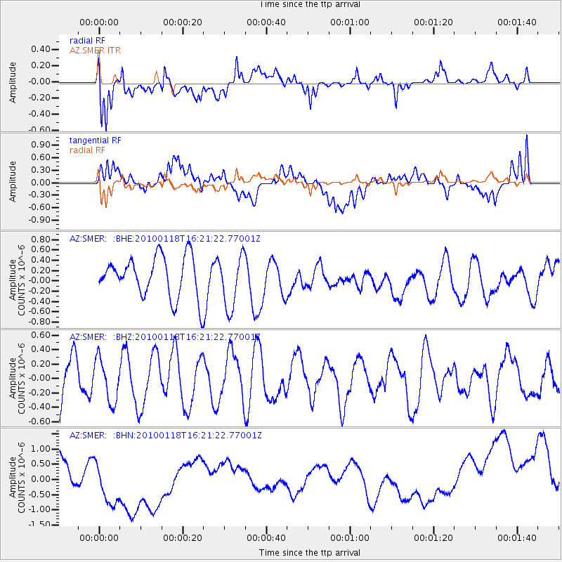
SMER AZ.SMER - Earthquake Result Viewer
*The percent match for this event was below the threshold and hence no stack was calculated.
| Earthquake location: |
Santa Cruz Islands |
| Earthquake latitude/longitude: |
-12.5/166.3 |
| Earthquake time(UTC): |
2010/01/18 (018) 16:09:14 GMT |
| Earthquake Depth: |
10 km |
| Earthquake Magnitude: |
5.5 MB, 5.4 MS, 5.7 MW, 5.7 MW |
| Earthquake Catalog/Contributor: |
WHDF/NEIC |
|
| Network: |
AZ ANZA Regional Network |
| Station: |
SMER AZ.SMER |
| Lat/Lon: |
33.46 N/117.17 W |
| Elevation: |
355 m |
|
| Distance: |
85.9 deg |
| Az: |
54.602 deg |
| Baz: |
252.233 deg |
| Ray Param: |
$rayparam |
*The percent match for this event was below the threshold and hence was not used in the summary stack. |
|
| Radial Match: |
45.99826 % |
| Radial Bump: |
400 |
| Transverse Match: |
23.951677 % |
| Transverse Bump: |
400 |
| SOD ConfigId: |
296938 |
| Insert Time: |
2010-04-06 21:48:52.931 +0000 |
| GWidth: |
2.5 |
| Max Bumps: |
400 |
| Tol: |
0.001 |
|
Signal To Noise
| Channel | StoN | STA | LTA |
| AZ:SMER: :BHZ:20100118T16:21:22.77001Z | 0.86249965 | 3.046541E-7 | 3.5322228E-7 |
| AZ:SMER: :BHN:20100118T16:21:22.77001Z | 2.309843 | 9.693424E-7 | 4.1965725E-7 |
| AZ:SMER: :BHE:20100118T16:21:22.77001Z | 1.3610804 | 5.3165616E-7 | 3.9061337E-7 |
| Arrivals |
| Ps | |
| PpPs | |
| PsPs/PpSs | |


