You are here: Home > Network List > GS - US Geological Survey Networks Stations List
> Station OK051 E0350 and S34600 roads, Ralston OK > Earthquake Result Viewer
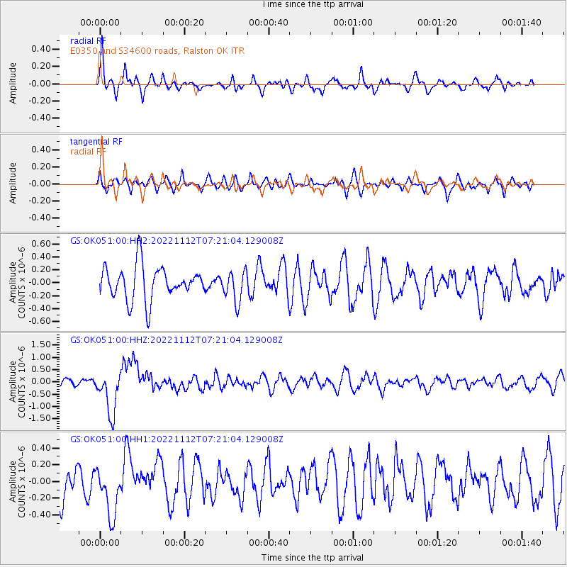
OK051 E0350 and S34600 roads, Ralston OK - Earthquake Result Viewer

| Earthquake location: |
Fiji Islands Region |
| Earthquake latitude/longitude: |
-20.1/-178.4 |
| Earthquake time(UTC): |
2022/11/12 (316) 07:09:14 GMT |
| Earthquake Depth: |
587 km |
| Earthquake Magnitude: |
7.0 mww |
| Earthquake Catalog/Contributor: |
NEIC PDE/us |
|
| Network: |
GS US Geological Survey Networks |
| Station: |
OK051 E0350 and S34600 roads, Ralston OK |
| Lat/Lon: |
36.50 N/96.84 W |
| Elevation: |
263 m |
|
| Distance: |
95.2 deg |
| Az: |
53.152 deg |
| Baz: |
248.964 deg |
| Ray Param: |
0.04023171 |
| Estimated Moho Depth: |
38.5 km |
| Estimated Crust Vp/Vs: |
2.01 |
| Assumed Crust Vp: |
6.483 km/s |
| Estimated Crust Vs: |
3.229 km/s |
| Estimated Crust Poisson's Ratio: |
0.33 |
|
| Radial Match: |
80.03936 % |
| Radial Bump: |
400 |
| Transverse Match: |
41.93685 % |
| Transverse Bump: |
371 |
| SOD ConfigId: |
29756493 |
| Insert Time: |
2022-11-26 07:30:03.751 +0000 |
| GWidth: |
2.5 |
| Max Bumps: |
400 |
| Tol: |
0.001 |
|
Signal To Noise
| Channel | StoN | STA | LTA |
| GS:OK051:00:HHZ:20221112T07:21:04.129008Z | 4.6090574 | 9.104223E-7 | 1.9752896E-7 |
| GS:OK051:00:HH1:20221112T07:21:04.129008Z | 1.7122308 | 3.0470005E-7 | 1.77955E-7 |
| GS:OK051:00:HH2:20221112T07:21:04.129008Z | 0.94774103 | 2.4451268E-7 | 2.5799525E-7 |
| Arrivals |
| Ps | 6.1 SECOND |
| PpPs | 18 SECOND |
| PsPs/PpSs | 24 SECOND |


