You are here: Home > Network List > TA - USArray Transportable Network (new EarthScope stations) Stations List
> Station 528A Cox Ranch, Sanderson, TX, USA > Earthquake Result Viewer
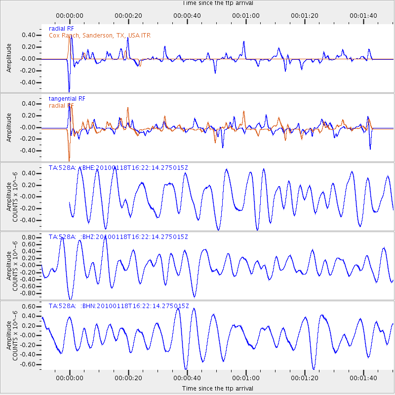
528A Cox Ranch, Sanderson, TX, USA - Earthquake Result Viewer
*The percent match for this event was below the threshold and hence no stack was calculated.
| Earthquake location: |
Santa Cruz Islands |
| Earthquake latitude/longitude: |
-12.5/166.3 |
| Earthquake time(UTC): |
2010/01/18 (018) 16:09:14 GMT |
| Earthquake Depth: |
10 km |
| Earthquake Magnitude: |
5.5 MB, 5.4 MS, 5.7 MW, 5.7 MW |
| Earthquake Catalog/Contributor: |
WHDF/NEIC |
|
| Network: |
TA USArray Transportable Network (new EarthScope stations) |
| Station: |
528A Cox Ranch, Sanderson, TX, USA |
| Lat/Lon: |
30.16 N/102.79 W |
| Elevation: |
1183 m |
|
| Distance: |
96.9 deg |
| Az: |
60.735 deg |
| Baz: |
259.659 deg |
| Ray Param: |
$rayparam |
*The percent match for this event was below the threshold and hence was not used in the summary stack. |
|
| Radial Match: |
59.155857 % |
| Radial Bump: |
400 |
| Transverse Match: |
72.32002 % |
| Transverse Bump: |
400 |
| SOD ConfigId: |
296938 |
| Insert Time: |
2010-04-06 21:51:59.882 +0000 |
| GWidth: |
2.5 |
| Max Bumps: |
400 |
| Tol: |
0.001 |
|
Signal To Noise
| Channel | StoN | STA | LTA |
| TA:528A: :BHZ:20100118T16:22:14.275015Z | 2.0854754 | 6.296912E-7 | 3.0194133E-7 |
| TA:528A: :BHN:20100118T16:22:14.275015Z | 1.1609485 | 2.4752458E-7 | 2.1320893E-7 |
| TA:528A: :BHE:20100118T16:22:14.275015Z | 0.8448781 | 2.4527577E-7 | 2.9030906E-7 |
| Arrivals |
| Ps | |
| PpPs | |
| PsPs/PpSs | |


