You are here: Home > Network List > CB - China National Seismic Network Stations List
> Station DL2 Dalian,Liaoning Province > Earthquake Result Viewer
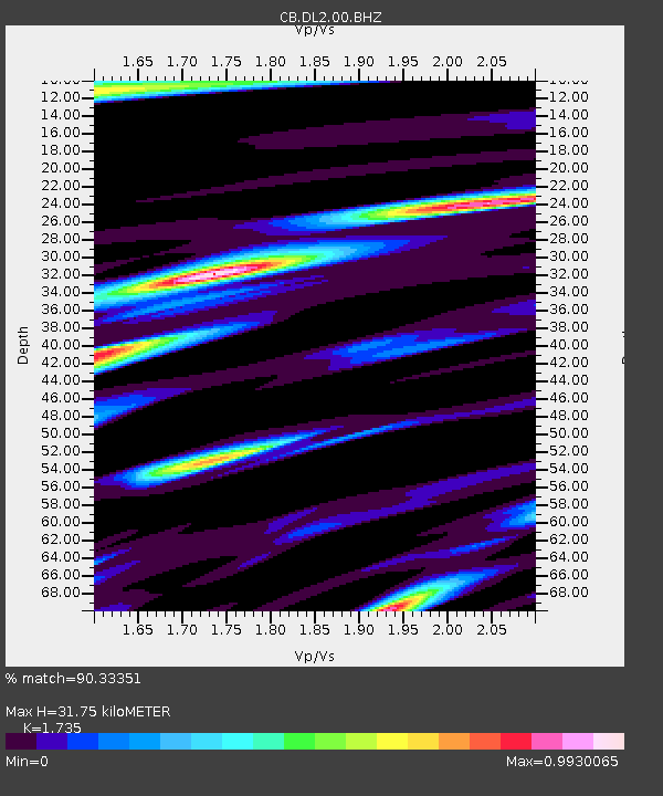
DL2 Dalian,Liaoning Province - Earthquake Result Viewer
| Earthquake location: |
Admiralty Islands Region, P.N.G. |
| Earthquake latitude/longitude: |
-1.4/148.1 |
| Earthquake time(UTC): |
2017/08/27 (239) 04:17:51 GMT |
| Earthquake Depth: |
10 km |
| Earthquake Magnitude: |
6.6 Mi |
| Earthquake Catalog/Contributor: |
NEIC PDE/at |
|
| Network: |
CB China National Seismic Network |
| Station: |
DL2 Dalian,Liaoning Province |
| Lat/Lon: |
38.91 N/121.63 E |
| Elevation: |
65 m |
|
| Distance: |
46.9 deg |
| Az: |
331.563 deg |
| Baz: |
142.401 deg |
| Ray Param: |
0.07033612 |
| Estimated Moho Depth: |
31.75 km |
| Estimated Crust Vp/Vs: |
1.74 |
| Assumed Crust Vp: |
6.134 km/s |
| Estimated Crust Vs: |
3.535 km/s |
| Estimated Crust Poisson's Ratio: |
0.25 |
|
| Radial Match: |
90.33351 % |
| Radial Bump: |
400 |
| Transverse Match: |
75.810616 % |
| Transverse Bump: |
400 |
| SOD ConfigId: |
2973751 |
| Insert Time: |
2018-10-08 21:32:28.067 +0000 |
| GWidth: |
2.5 |
| Max Bumps: |
400 |
| Tol: |
0.001 |
|

Signal To Noise
| Channel | StoN | STA | LTA |
| CB:DL2:00:BHZ:20170827T04:25:51.269989Z | 2.355153 | 6.940215E-7 | 2.946821E-7 |
| CB:DL2:00:BHN:20170827T04:25:51.269989Z | 1.8463106 | 4.3067521E-7 | 2.332626E-7 |
| CB:DL2:00:BHE:20170827T04:25:51.269989Z | 1.2297707 | 2.5429668E-7 | 2.0678384E-7 |
| Arrivals |
| Ps | 4.0 SECOND |
| PpPs | 13 SECOND |
| PsPs/PpSs | 17 SECOND |


