You are here: Home > Network List > IW - Intermountain West Stations List
> Station PLID Pearl Lake, Idaho, USA > Earthquake Result Viewer
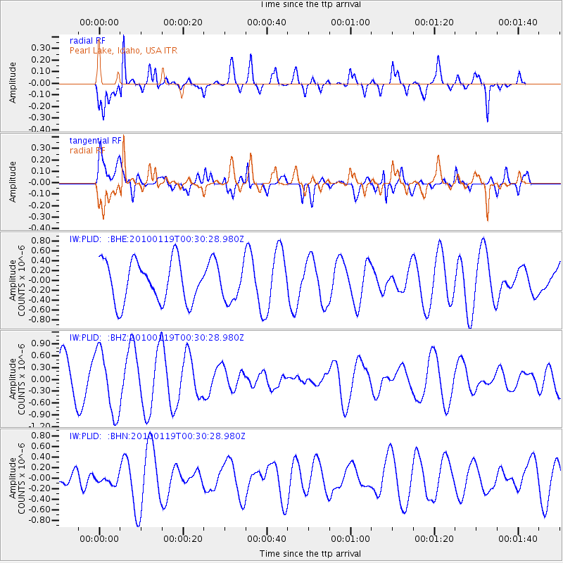
PLID Pearl Lake, Idaho, USA - Earthquake Result Viewer
*The percent match for this event was below the threshold and hence no stack was calculated.
| Earthquake location: |
Solomon Islands |
| Earthquake latitude/longitude: |
-9.0/158.1 |
| Earthquake time(UTC): |
2010/01/19 (019) 00:17:48 GMT |
| Earthquake Depth: |
39 km |
| Earthquake Magnitude: |
5.5 MB, 5.4 MS |
| Earthquake Catalog/Contributor: |
WHDF/NEIC |
|
| Network: |
IW Intermountain West |
| Station: |
PLID Pearl Lake, Idaho, USA |
| Lat/Lon: |
45.09 N/116.00 W |
| Elevation: |
2164 m |
|
| Distance: |
93.4 deg |
| Az: |
45.063 deg |
| Baz: |
260.802 deg |
| Ray Param: |
$rayparam |
*The percent match for this event was below the threshold and hence was not used in the summary stack. |
|
| Radial Match: |
69.36302 % |
| Radial Bump: |
342 |
| Transverse Match: |
61.697254 % |
| Transverse Bump: |
400 |
| SOD ConfigId: |
296938 |
| Insert Time: |
2010-04-06 21:58:11.917 +0000 |
| GWidth: |
2.5 |
| Max Bumps: |
400 |
| Tol: |
0.001 |
|
Signal To Noise
| Channel | StoN | STA | LTA |
| IW:PLID: :BHZ:20100119T00:30:28.980Z | 1.9322449 | 8.106436E-7 | 4.1953462E-7 |
| IW:PLID: :BHN:20100119T00:30:28.980Z | 0.39299121 | 8.312388E-8 | 2.1151588E-7 |
| IW:PLID: :BHE:20100119T00:30:28.980Z | 0.8426436 | 3.4882478E-7 | 4.1396478E-7 |
| Arrivals |
| Ps | |
| PpPs | |
| PsPs/PpSs | |


