You are here: Home > Network List > UU - University of Utah Regional Network Stations List
> Station FOR8 FORGE > Earthquake Result Viewer
FOR8 FORGE - Earthquake Result Viewer
| Earthquake location: |
Fiji Islands Region |
| Earthquake latitude/longitude: |
-20.1/-178.4 |
| Earthquake time(UTC): |
2022/11/12 (316) 07:09:14 GMT |
| Earthquake Depth: |
587 km |
| Earthquake Magnitude: |
7.0 mww |
| Earthquake Catalog/Contributor: |
NEIC PDE/us |
|
| Network: |
UU University of Utah Regional Network |
| Station: |
FOR8 FORGE |
| Lat/Lon: |
38.53 N/113.08 W |
| Elevation: |
1654 m |
|
| Distance: |
84.5 deg |
| Az: |
45.708 deg |
| Baz: |
239.051 deg |
| Ray Param: |
0.043727595 |
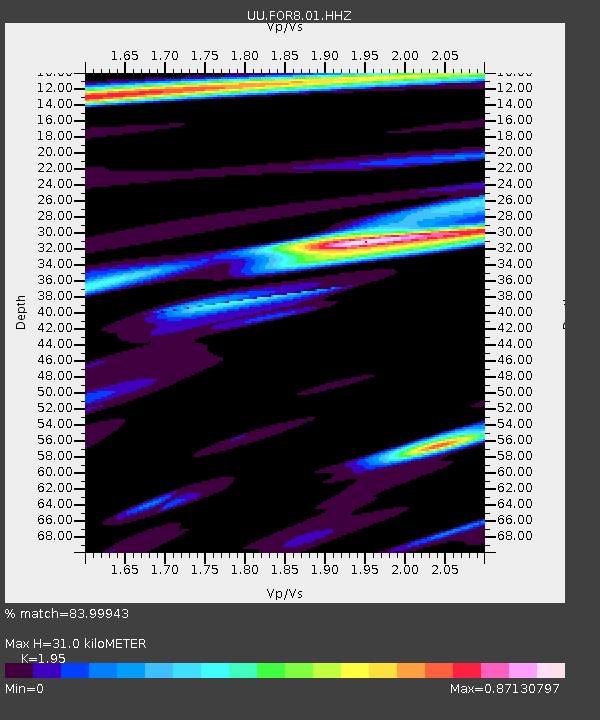
| Estimated Moho Depth: |
31.0 km |
| Estimated Crust Vp/Vs: |
1.95 |
| Assumed Crust Vp: |
6.276 km/s |
| Estimated Crust Vs: |
3.218 km/s |
| Estimated Crust Poisson's Ratio: |
0.32 |
|
| Radial Match: |
83.99943 % |
| Radial Bump: |
400 |
| Transverse Match: |
68.570595 % |
| Transverse Bump: |
400 |
| SOD ConfigId: |
29756493 |
| Insert Time: |
2022-11-26 07:46:36.802 +0000 |
| GWidth: |
2.5 |
| Max Bumps: |
400 |
| Tol: |
0.001 |
|

Signal To Noise
| Channel | StoN | STA | LTA |
| UU:FOR8:01:HHZ:20221112T07:20:14.600016Z | 31.65731 | 3.840063E-6 | 1.2130099E-7 |
| UU:FOR8:01:HHN:20221112T07:20:14.600016Z | 5.439337 | 9.746091E-7 | 1.7917793E-7 |
| UU:FOR8:01:HHE:20221112T07:20:14.600016Z | 4.254894 | 7.5567146E-7 | 1.7760055E-7 |
| Arrivals |
| Ps | 4.8 SECOND |
| PpPs | 14 SECOND |
| PsPs/PpSs | 19 SECOND |


