You are here: Home > Network List > UW - Pacific Northwest Regional Seismic Network Stations List
> Station CCRK Sunnyside, WA, USA > Earthquake Result Viewer
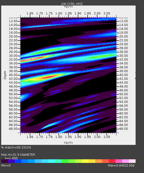
CCRK Sunnyside, WA, USA - Earthquake Result Viewer
| Earthquake location: |
Fiji Islands Region |
| Earthquake latitude/longitude: |
-20.1/-178.4 |
| Earthquake time(UTC): |
2022/11/12 (316) 07:09:14 GMT |
| Earthquake Depth: |
587 km |
| Earthquake Magnitude: |
7.0 mww |
| Earthquake Catalog/Contributor: |
NEIC PDE/us |
|
| Network: |
UW Pacific Northwest Regional Seismic Network |
| Station: |
CCRK Sunnyside, WA, USA |
| Lat/Lon: |
46.56 N/119.85 W |
| Elevation: |
561 m |
|
| Distance: |
84.8 deg |
| Az: |
36.219 deg |
| Baz: |
233.58 deg |
| Ray Param: |
0.04353375 |
| Estimated Moho Depth: |
31.5 km |
| Estimated Crust Vp/Vs: |
1.65 |
| Assumed Crust Vp: |
6.419 km/s |
| Estimated Crust Vs: |
3.879 km/s |
| Estimated Crust Poisson's Ratio: |
0.21 |
|
| Radial Match: |
85.33104 % |
| Radial Bump: |
400 |
| Transverse Match: |
71.5167 % |
| Transverse Bump: |
400 |
| SOD ConfigId: |
29756493 |
| Insert Time: |
2022-11-26 07:46:58.751 +0000 |
| GWidth: |
2.5 |
| Max Bumps: |
400 |
| Tol: |
0.001 |
|

Signal To Noise
| Channel | StoN | STA | LTA |
| UW:CCRK: :HHZ:20221112T07:20:15.939982Z | 24.338116 | 7.363411E-6 | 3.0254648E-7 |
| UW:CCRK: :HHN:20221112T07:20:15.939982Z | 13.890192 | 1.9367199E-6 | 1.3943075E-7 |
| UW:CCRK: :HHE:20221112T07:20:15.939982Z | 6.2287097 | 1.4084527E-6 | 2.261227E-7 |
| Arrivals |
| Ps | 3.3 SECOND |
| PpPs | 13 SECOND |
| PsPs/PpSs | 16 SECOND |


