You are here: Home > Network List > UW - Pacific Northwest Regional Seismic Network Stations List
> Station H2O H2O, Hanford, WA, USA > Earthquake Result Viewer
H2O H2O, Hanford, WA, USA - Earthquake Result Viewer
| Earthquake location: |
Fiji Islands Region |
| Earthquake latitude/longitude: |
-20.1/-178.4 |
| Earthquake time(UTC): |
2022/11/12 (316) 07:09:14 GMT |
| Earthquake Depth: |
587 km |
| Earthquake Magnitude: |
7.0 mww |
| Earthquake Catalog/Contributor: |
NEIC PDE/us |
|
| Network: |
UW Pacific Northwest Regional Seismic Network |
| Station: |
H2O H2O, Hanford, WA, USA |
| Lat/Lon: |
46.40 N/119.42 W |
| Elevation: |
175 m |
|
| Distance: |
84.9 deg |
| Az: |
36.528 deg |
| Baz: |
233.92 deg |
| Ray Param: |
0.043432105 |
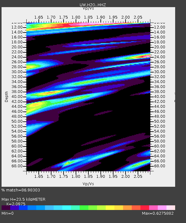
| Estimated Moho Depth: |
23.5 km |
| Estimated Crust Vp/Vs: |
2.10 |
| Assumed Crust Vp: |
6.419 km/s |
| Estimated Crust Vs: |
3.06 km/s |
| Estimated Crust Poisson's Ratio: |
0.35 |
|
| Radial Match: |
86.98303 % |
| Radial Bump: |
400 |
| Transverse Match: |
69.985146 % |
| Transverse Bump: |
400 |
| SOD ConfigId: |
29756493 |
| Insert Time: |
2022-11-26 07:47:31.585 +0000 |
| GWidth: |
2.5 |
| Max Bumps: |
400 |
| Tol: |
0.001 |
|

Signal To Noise
| Channel | StoN | STA | LTA |
| UW:H2O: :HHZ:20221112T07:20:16.629984Z | 23.824474 | 7.497177E-6 | 3.1468386E-7 |
| UW:H2O: :HHN:20221112T07:20:16.629984Z | 11.902764 | 1.6080762E-6 | 1.3510108E-7 |
| UW:H2O: :HHE:20221112T07:20:16.629984Z | 10.358634 | 1.947039E-6 | 1.8796293E-7 |
| Arrivals |
| Ps | 4.1 SECOND |
| PpPs | 11 SECOND |
| PsPs/PpSs | 15 SECOND |


