You are here: Home > Network List > CC - Cascade Chain Volcano Monitoring Stations List
> Station VALT Mt. St. Helens Crater, WA > Earthquake Result Viewer
VALT Mt. St. Helens Crater, WA - Earthquake Result Viewer
| Earthquake location: |
Cuba Region |
| Earthquake latitude/longitude: |
19.0/-80.8 |
| Earthquake time(UTC): |
2010/01/19 (019) 14:23:38 GMT |
| Earthquake Depth: |
10 km |
| Earthquake Magnitude: |
5.7 MB, 5.4 MS, 5.9 MW, 5.9 MW |
| Earthquake Catalog/Contributor: |
WHDF/NEIC |
|
| Network: |
CC Cascade Chain Volcano Monitoring |
| Station: |
VALT Mt. St. Helens Crater, WA |
| Lat/Lon: |
46.21 N/122.19 W |
| Elevation: |
1681 m |
|
| Distance: |
43.5 deg |
| Az: |
318.133 deg |
| Baz: |
114.577 deg |
| Ray Param: |
0.072538674 |
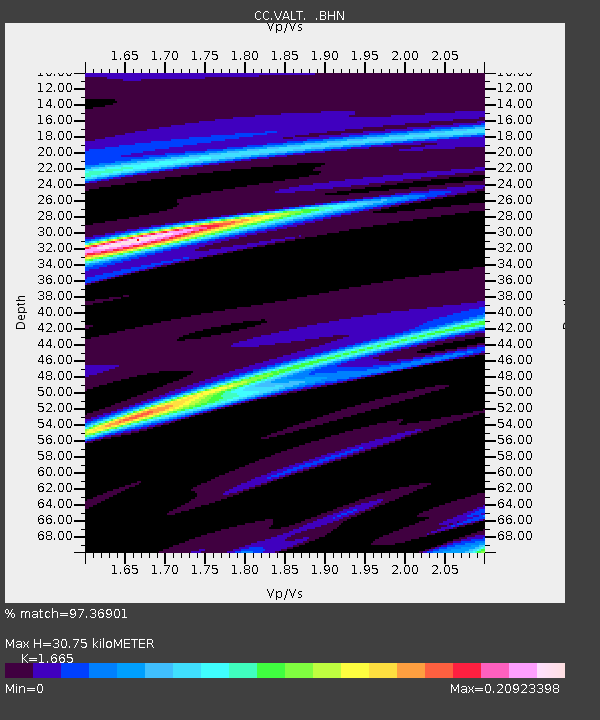
| Estimated Moho Depth: |
30.75 km |
| Estimated Crust Vp/Vs: |
1.66 |
| Assumed Crust Vp: |
6.566 km/s |
| Estimated Crust Vs: |
3.944 km/s |
| Estimated Crust Poisson's Ratio: |
0.22 |
|
| Radial Match: |
97.36901 % |
| Radial Bump: |
95 |
| Transverse Match: |
97.50323 % |
| Transverse Bump: |
92 |
| SOD ConfigId: |
296938 |
| Insert Time: |
2010-04-06 22:00:54.780 +0000 |
| GWidth: |
2.5 |
| Max Bumps: |
400 |
| Tol: |
0.001 |
|

Signal To Noise
| Channel | StoN | STA | LTA |
| CC:VALT: :BHZ:20100119T14:31:11.100Z | 1.442389 | 2.1017611E-7 | 1.4571388E-7 |
| CC:VALT: :BHN:20100119T14:31:11.100Z | 1.4485058 | 2.091869E-7 | 1.4441564E-7 |
| CC:VALT: :BHE:20100119T14:31:11.100Z | 1.1161115 | 1.5297333E-7 | 1.3705917E-7 |
| Arrivals |
| Ps | 3.4 SECOND |
| PpPs | 12 SECOND |
| PsPs/PpSs | 15 SECOND |


