You are here: Home > Network List > UM - University of Montana - Missoula Stations List
> Station GBMT Granite Butte > Earthquake Result Viewer
GBMT Granite Butte - Earthquake Result Viewer
| Earthquake location: |
Admiralty Islands Region, P.N.G. |
| Earthquake latitude/longitude: |
-1.4/148.1 |
| Earthquake time(UTC): |
2017/08/27 (239) 04:17:51 GMT |
| Earthquake Depth: |
10 km |
| Earthquake Magnitude: |
6.6 Mi |
| Earthquake Catalog/Contributor: |
NEIC PDE/at |
|
| Network: |
UM University of Montana - Missoula |
| Station: |
GBMT Granite Butte |
| Lat/Lon: |
46.86 N/112.46 W |
| Elevation: |
2235 m |
|
| Distance: |
97.5 deg |
| Az: |
43.059 deg |
| Baz: |
275.943 deg |
| Ray Param: |
0.040201057 |
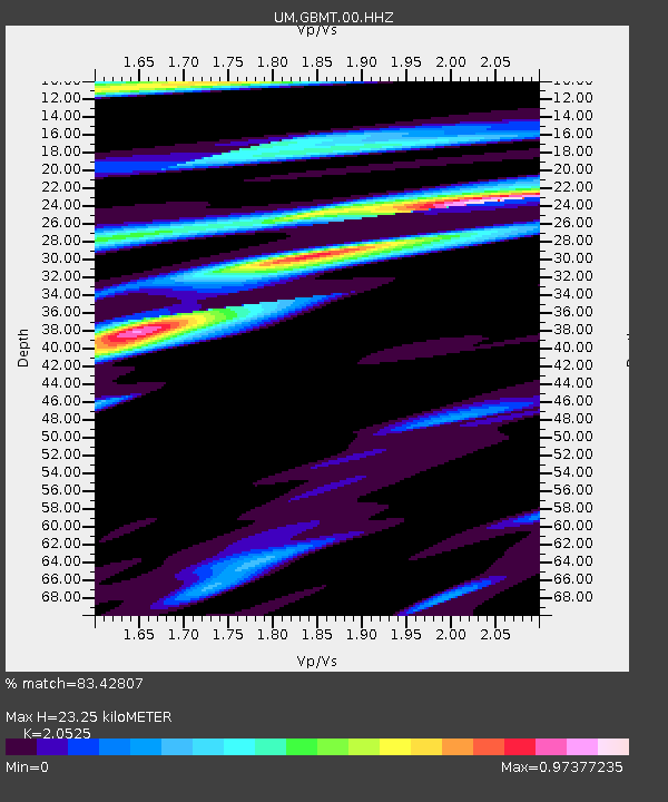
| Estimated Moho Depth: |
23.25 km |
| Estimated Crust Vp/Vs: |
2.05 |
| Assumed Crust Vp: |
6.353 km/s |
| Estimated Crust Vs: |
3.095 km/s |
| Estimated Crust Poisson's Ratio: |
0.34 |
|
| Radial Match: |
83.42807 % |
| Radial Bump: |
400 |
| Transverse Match: |
47.466965 % |
| Transverse Bump: |
400 |
| SOD ConfigId: |
2973751 |
| Insert Time: |
2018-10-08 21:33:27.320 +0000 |
| GWidth: |
2.5 |
| Max Bumps: |
400 |
| Tol: |
0.001 |
|

Signal To Noise
| Channel | StoN | STA | LTA |
| UM:GBMT:00:HHZ:20170827T04:30:53.72998Z | 1.7430165 | 1.0680956E-7 | 6.127858E-8 |
| UM:GBMT:00:HHN:20170827T04:30:53.72998Z | 1.1640242 | 1.0953888E-7 | 9.4103605E-8 |
| UM:GBMT:00:HHE:20170827T04:30:53.72998Z | 1.1545976 | 6.5896906E-8 | 5.707348E-8 |
| Arrivals |
| Ps | 3.9 SECOND |
| PpPs | 11 SECOND |
| PsPs/PpSs | 15 SECOND |


