You are here: Home > Network List > CB - China National Seismic Network Stations List
> Station CN2 Changchun,Jilin Province > Earthquake Result Viewer
CN2 Changchun,Jilin Province - Earthquake Result Viewer
| Earthquake location: |
Southern Sumatra, Indonesia |
| Earthquake latitude/longitude: |
-1.2/99.7 |
| Earthquake time(UTC): |
2017/08/31 (243) 17:06:55 GMT |
| Earthquake Depth: |
43 km |
| Earthquake Magnitude: |
6.3 Mww |
| Earthquake Catalog/Contributor: |
NEIC PDE/us |
|
| Network: |
CB China National Seismic Network |
| Station: |
CN2 Changchun,Jilin Province |
| Lat/Lon: |
43.48 N/125.26 E |
| Elevation: |
223 m |
|
| Distance: |
50.0 deg |
| Az: |
24.213 deg |
| Baz: |
214.285 deg |
| Ray Param: |
0.06824056 |
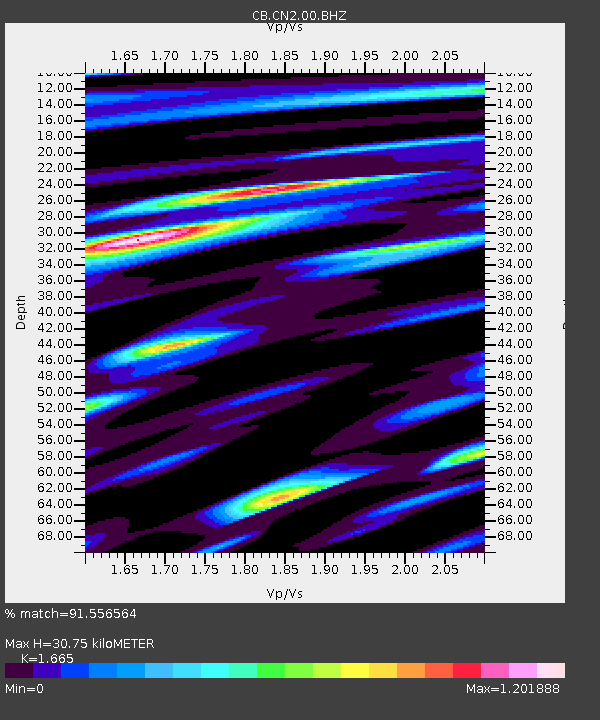
| Estimated Moho Depth: |
30.75 km |
| Estimated Crust Vp/Vs: |
1.66 |
| Assumed Crust Vp: |
6.459 km/s |
| Estimated Crust Vs: |
3.88 km/s |
| Estimated Crust Poisson's Ratio: |
0.22 |
|
| Radial Match: |
91.556564 % |
| Radial Bump: |
265 |
| Transverse Match: |
78.62419 % |
| Transverse Bump: |
400 |
| SOD ConfigId: |
2973751 |
| Insert Time: |
2018-10-08 21:38:32.309 +0000 |
| GWidth: |
2.5 |
| Max Bumps: |
400 |
| Tol: |
0.001 |
|

Signal To Noise
| Channel | StoN | STA | LTA |
| CB:CN2:00:BHZ:20170831T17:15:15.230011Z | 16.290895 | 1.1041407E-6 | 6.777655E-8 |
| CB:CN2:00:BHN:20170831T17:15:15.230011Z | 9.419325 | 7.8374353E-7 | 8.320591E-8 |
| CB:CN2:00:BHE:20170831T17:15:15.230011Z | 6.390954 | 5.7853566E-7 | 9.052414E-8 |
| Arrivals |
| Ps | 3.4 SECOND |
| PpPs | 12 SECOND |
| PsPs/PpSs | 15 SECOND |


