You are here: Home > Network List > UW - Pacific Northwest Regional Seismic Network Stations List
> Station HDW Hoodsport, WA, USA > Earthquake Result Viewer
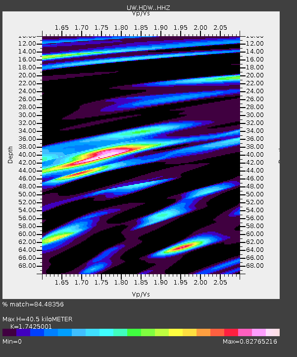
HDW Hoodsport, WA, USA - Earthquake Result Viewer
| Earthquake location: |
Fiji Islands Region |
| Earthquake latitude/longitude: |
-20.1/-178.4 |
| Earthquake time(UTC): |
2022/11/12 (316) 07:09:14 GMT |
| Earthquake Depth: |
587 km |
| Earthquake Magnitude: |
7.0 mww |
| Earthquake Catalog/Contributor: |
NEIC PDE/us |
|
| Network: |
UW Pacific Northwest Regional Seismic Network |
| Station: |
HDW Hoodsport, WA, USA |
| Lat/Lon: |
47.65 N/123.06 W |
| Elevation: |
1006 m |
|
| Distance: |
83.7 deg |
| Az: |
34.009 deg |
| Baz: |
231.02 deg |
| Ray Param: |
0.044272408 |
| Estimated Moho Depth: |
40.5 km |
| Estimated Crust Vp/Vs: |
1.74 |
| Assumed Crust Vp: |
6.566 km/s |
| Estimated Crust Vs: |
3.768 km/s |
| Estimated Crust Poisson's Ratio: |
0.25 |
|
| Radial Match: |
84.48356 % |
| Radial Bump: |
400 |
| Transverse Match: |
87.908195 % |
| Transverse Bump: |
400 |
| SOD ConfigId: |
29756493 |
| Insert Time: |
2022-11-26 07:51:13.748 +0000 |
| GWidth: |
2.5 |
| Max Bumps: |
400 |
| Tol: |
0.001 |
|

Signal To Noise
| Channel | StoN | STA | LTA |
| UW:HDW: :HHZ:20221112T07:20:10.759989Z | 30.54075 | 6.183116E-6 | 2.0245463E-7 |
| UW:HDW: :HHN:20221112T07:20:10.759989Z | 8.452469 | 2.055016E-6 | 2.4312612E-7 |
| UW:HDW: :HHE:20221112T07:20:10.759989Z | 3.5726242 | 9.4050534E-7 | 2.6325336E-7 |
| Arrivals |
| Ps | 4.7 SECOND |
| PpPs | 16 SECOND |
| PsPs/PpSs | 21 SECOND |


