You are here: Home > Network List > WW - Idaho Seismic Network () Stations List
> Station TYLR Tyler Ranch Idaho > Earthquake Result Viewer
TYLR Tyler Ranch Idaho - Earthquake Result Viewer
| Earthquake location: |
Fiji Islands Region |
| Earthquake latitude/longitude: |
-20.1/-178.4 |
| Earthquake time(UTC): |
2022/11/12 (316) 07:09:14 GMT |
| Earthquake Depth: |
587 km |
| Earthquake Magnitude: |
7.0 mww |
| Earthquake Catalog/Contributor: |
NEIC PDE/us |
|
| Network: |
WW Idaho Seismic Network () |
| Station: |
TYLR Tyler Ranch Idaho |
| Lat/Lon: |
45.10 N/114.85 W |
| Elevation: |
1203 m |
|
| Distance: |
86.8 deg |
| Az: |
39.409 deg |
| Baz: |
237.393 deg |
| Ray Param: |
0.042093296 |
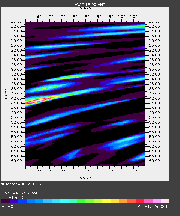
| Estimated Moho Depth: |
42.75 km |
| Estimated Crust Vp/Vs: |
1.65 |
| Assumed Crust Vp: |
6.577 km/s |
| Estimated Crust Vs: |
3.992 km/s |
| Estimated Crust Poisson's Ratio: |
0.21 |
|
| Radial Match: |
90.598625 % |
| Radial Bump: |
400 |
| Transverse Match: |
86.77602 % |
| Transverse Bump: |
400 |
| SOD ConfigId: |
29756493 |
| Insert Time: |
2022-11-26 07:52:01.931 +0000 |
| GWidth: |
2.5 |
| Max Bumps: |
400 |
| Tol: |
0.001 |
|
Signal To Noise
| Channel | StoN | STA | LTA |
| WW:TYLR:00:HHZ:20221112T07:20:25.720011Z | 47.49431 | 5.1150637E-6 | 1.07698455E-7 |
| WW:TYLR:00:HHN:20221112T07:20:25.720011Z | 16.596725 | 1.0450585E-6 | 6.296776E-8 |
| WW:TYLR:00:HHE:20221112T07:20:25.720011Z | 12.735839 | 1.1365906E-6 | 8.9243485E-8 |
| Arrivals |
| Ps | 4.3 SECOND |
| PpPs | 17 SECOND |
| PsPs/PpSs | 21 SECOND |


