You are here: Home > Network List > CB - China National Seismic Network Stations List
> Station LYN Luoyang,Henan Province > Earthquake Result Viewer
LYN Luoyang,Henan Province - Earthquake Result Viewer
| Earthquake location: |
Southern Sumatra, Indonesia |
| Earthquake latitude/longitude: |
-1.2/99.7 |
| Earthquake time(UTC): |
2017/08/31 (243) 17:06:55 GMT |
| Earthquake Depth: |
43 km |
| Earthquake Magnitude: |
6.3 Mww |
| Earthquake Catalog/Contributor: |
NEIC PDE/us |
|
| Network: |
CB China National Seismic Network |
| Station: |
LYN Luoyang,Henan Province |
| Lat/Lon: |
34.55 N/112.47 E |
| Elevation: |
170 m |
|
| Distance: |
37.5 deg |
| Az: |
17.46 deg |
| Baz: |
201.311 deg |
| Ray Param: |
0.07600653 |
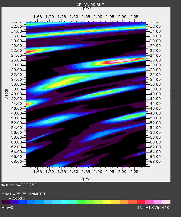
| Estimated Moho Depth: |
25.75 km |
| Estimated Crust Vp/Vs: |
2.00 |
| Assumed Crust Vp: |
6.155 km/s |
| Estimated Crust Vs: |
3.074 km/s |
| Estimated Crust Poisson's Ratio: |
0.33 |
|
| Radial Match: |
93.1753 % |
| Radial Bump: |
400 |
| Transverse Match: |
69.246376 % |
| Transverse Bump: |
400 |
| SOD ConfigId: |
2973751 |
| Insert Time: |
2018-10-08 21:38:42.162 +0000 |
| GWidth: |
2.5 |
| Max Bumps: |
400 |
| Tol: |
0.001 |
|

Signal To Noise
| Channel | StoN | STA | LTA |
| CB:LYN:00:BHZ:20170831T17:13:34.920013Z | 17.747997 | 3.7648488E-6 | 2.1212809E-7 |
| CB:LYN:00:BHN:20170831T17:13:34.920013Z | 10.715949 | 2.0094378E-6 | 1.8751842E-7 |
| CB:LYN:00:BHE:20170831T17:13:34.920013Z | 3.7541308 | 8.350314E-7 | 2.2243002E-7 |
| Arrivals |
| Ps | 4.4 SECOND |
| PpPs | 12 SECOND |
| PsPs/PpSs | 16 SECOND |


