You are here: Home > Network List > TA - USArray Transportable Network (new EarthScope stations) Stations List
> Station I28A Midland, SD, USA > Earthquake Result Viewer
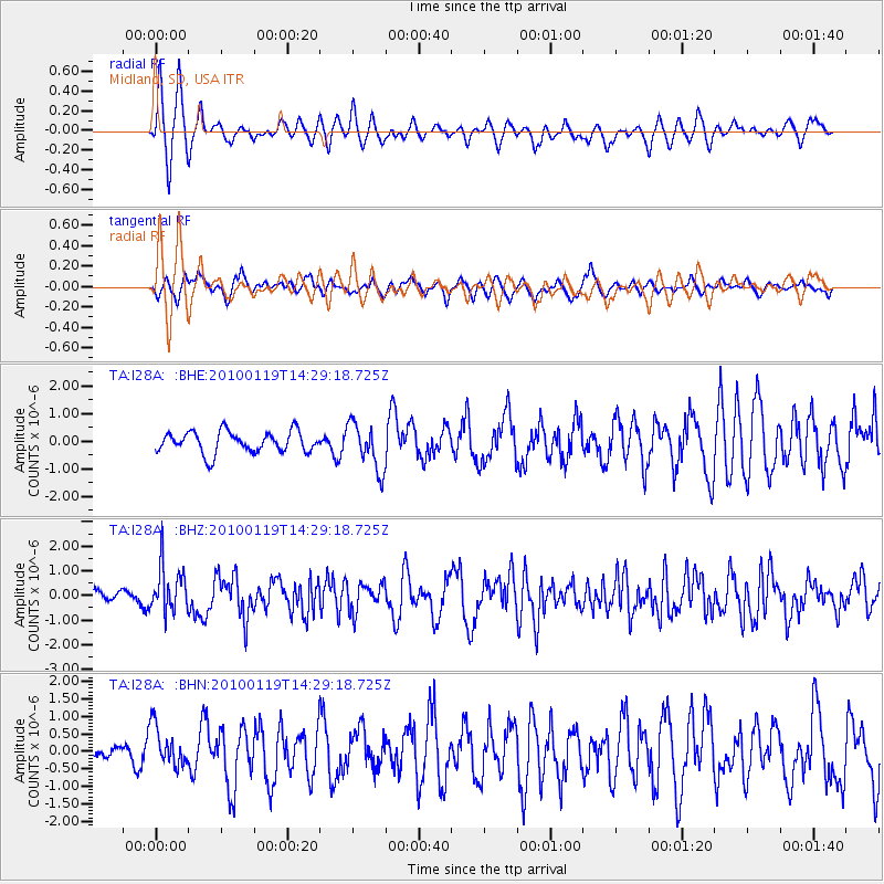
I28A Midland, SD, USA - Earthquake Result Viewer
*The percent match for this event was below the threshold and hence no stack was calculated.
| Earthquake location: |
Cuba Region |
| Earthquake latitude/longitude: |
19.0/-80.8 |
| Earthquake time(UTC): |
2010/01/19 (019) 14:23:38 GMT |
| Earthquake Depth: |
10 km |
| Earthquake Magnitude: |
5.7 MB, 5.4 MS, 5.9 MW, 5.9 MW |
| Earthquake Catalog/Contributor: |
WHDF/NEIC |
|
| Network: |
TA USArray Transportable Network (new EarthScope stations) |
| Station: |
I28A Midland, SD, USA |
| Lat/Lon: |
44.00 N/101.17 W |
| Elevation: |
655 m |
|
| Distance: |
30.2 deg |
| Az: |
330.056 deg |
| Baz: |
139.124 deg |
| Ray Param: |
$rayparam |
*The percent match for this event was below the threshold and hence was not used in the summary stack. |
|
| Radial Match: |
71.438576 % |
| Radial Bump: |
400 |
| Transverse Match: |
50.88216 % |
| Transverse Bump: |
380 |
| SOD ConfigId: |
296938 |
| Insert Time: |
2010-04-06 22:10:08.122 +0000 |
| GWidth: |
2.5 |
| Max Bumps: |
400 |
| Tol: |
0.001 |
|
Signal To Noise
| Channel | StoN | STA | LTA |
| TA:I28A: :BHZ:20100119T14:29:18.725Z | 2.8309195 | 9.491586E-7 | 3.3528278E-7 |
| TA:I28A: :BHN:20100119T14:29:18.725Z | 1.1811818 | 5.966926E-7 | 5.0516576E-7 |
| TA:I28A: :BHE:20100119T14:29:18.725Z | 2.172692 | 8.4263127E-7 | 3.878282E-7 |
| Arrivals |
| Ps | |
| PpPs | |
| PsPs/PpSs | |


