You are here: Home > Network List > TX - Texas Seismological Network Stations List
> Station PLPT Palo Pinto > Earthquake Result Viewer
PLPT Palo Pinto - Earthquake Result Viewer
| Earthquake location: |
Near Coast Of Central Chile |
| Earthquake latitude/longitude: |
-37.5/-73.7 |
| Earthquake time(UTC): |
2022/11/13 (317) 02:24:57 GMT |
| Earthquake Depth: |
18 km |
| Earthquake Magnitude: |
6.2 mww |
| Earthquake Catalog/Contributor: |
NEIC PDE/us |
|
| Network: |
TX Texas Seismological Network |
| Station: |
PLPT Palo Pinto |
| Lat/Lon: |
32.81 N/98.32 W |
| Elevation: |
336 m |
|
| Distance: |
73.6 deg |
| Az: |
338.586 deg |
| Baz: |
159.817 deg |
| Ray Param: |
0.05290228 |
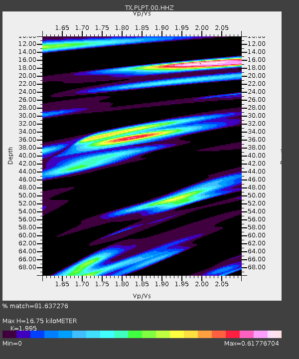
| Estimated Moho Depth: |
16.75 km |
| Estimated Crust Vp/Vs: |
2.00 |
| Assumed Crust Vp: |
6.426 km/s |
| Estimated Crust Vs: |
3.221 km/s |
| Estimated Crust Poisson's Ratio: |
0.33 |
|
| Radial Match: |
81.637276 % |
| Radial Bump: |
372 |
| Transverse Match: |
71.441986 % |
| Transverse Bump: |
400 |
| SOD ConfigId: |
29756493 |
| Insert Time: |
2022-11-27 03:11:15.250 +0000 |
| GWidth: |
2.5 |
| Max Bumps: |
400 |
| Tol: |
0.001 |
|

Signal To Noise
| Channel | StoN | STA | LTA |
| TX:PLPT:00:HHZ:20221113T02:35:58.410004Z | 3.0961564 | 4.965473E-7 | 1.6037538E-7 |
| TX:PLPT:00:HH1:20221113T02:35:58.410004Z | 1.155527 | 1.4606645E-7 | 1.2640679E-7 |
| TX:PLPT:00:HH2:20221113T02:35:58.410004Z | 1.2410167 | 2.0466449E-7 | 1.6491678E-7 |
| Arrivals |
| Ps | 2.7 SECOND |
| PpPs | 7.6 SECOND |
| PsPs/PpSs | 10 SECOND |


